Forrestdale geodata
Forrestdale (Western Australia) is a section of populated place; located in Australia in Australia/Perth (GMT+8) time zone. With population of 1,039 people, there are 3768 cities with bigger population in this country. Compared to other cities in Australia, 63% of cities are located further ↓South; 93.4% of cities are located further →East and 76.1% of cities have higher elevation than Forrestdale. Note1


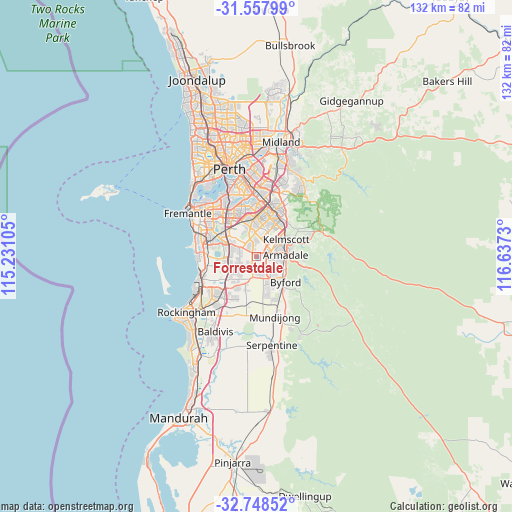
Forrestdale GPS coordinates[2]
32° 9' 18.72" South, 115° 56' 3.012" East
| Map corner | latitude | longitude |
|---|---|---|
| Upper-left | -31.55799°, | 115.23105° |
| Center: | -32.1552°, | 115.93417° |
| Lower-right: | -32.74852°, | 116.6373° |
| Map W x H: | 132.4×132.4 km | = 82.3×82.3mi |
| max Lat: | -10.58257° ⇑37% North |
| Forrestdale: | -32.1552° |
| min Lat: | ⇓63% South -43.31423° |
| min Long | Forrestdale | max Long |
| 113.53327° | 115.93417° | 153.61246° |
| W 6.6%⇐ | ⇒93.4% E |
Elevation
Elevation of Forrestdale is 18 m = 59 ft, and this is 104 m = 341 ft below average elevation for this country.
| Max E: |
1715 m = 5627 ft | 76.1% |
| Avg. | 122 m = 400 ft | |
| Forrestdale | 18 m = 59 ft | |
Min E: |
-2 m = -7 ft | 23.9% |
See also: Australia elevation on elevation.city.
Geographical zone
Forrestdale is located in South temperate zone (between Tropic of Capricorn and the Antarctic Circle). Distance of this Southern Tropic circle is 969.4 km =602.4 mi to North.| Distance of | km | miles | from Forrestdale |
|---|---|---|---|
| Equator | 3575.3 | 2221.6 | to North |
| Tropic Capricorn | 969.4 | 602.4 | to North |
| Antarctic Circle | 3825.9 | 2377.3 | to South |
| South Pole | 6431.7 | 3996.5 | to South |


Nearby cities:
15 places around Forrestdale: (largest is in red/bold)
• Armadale
7.1 km =4.4 mi,  81°
81°
• Atwell
6.6 km =4.1 mi,  281°
281°
• Aubin Grove
6.9 km =4.3 mi,  258°
258°
• Banjup
4.7 km =2.9 mi,  288°
288°
• Brookdale
6.5 km =4 mi,  101°
101°
• Champion Lakes
6.3 km =3.9 mi,  50°
50°
• Darling Downs
7 km =4.3 mi,  128°
128°
• Harrisdale
4.9 km =3 mi,  1°
1°
• Haynes
4.5 km =2.8 mi, 99°
• Hilbert
5.4 km =3.4 mi,  118°
118°
• Oakford
5.1 km =3.2 mi,  180°
180°
• Piara Waters
2.9 km =1.8 mi,  325°
325°
• Seville Grove
5.6 km =3.5 mi,  68°
68°
• Southern River
5.9 km =3.7 mi,  23°
23°
• Wandi
7 km =4.3 mi,  231°
231°
Sources, notices
• [Note1] Compared only with cities in Australia existing in our database
• [Src1] Map data: © OpenStreetMap contributors (CC-BY-SA)
• [Src2] Other city data from geonames.org with taken over terms of usage.
• [Src3] Geographical zone / Annual Mean Temperature by Robert A. Rohde @ Wikipedia
