Dynnyrne geodata
Dynnyrne (Tasmania) is a section of populated place; located in Australia in Australia/Hobart (GMT+11) time zone. With population of 1,578 people, there are 3212 cities with bigger population in this country. Compared to other cities in Australia, 99.5% of cities are located further ↑North; 51% of cities are located further →East and 76% of cities have lower elevation than Dynnyrne. Note1


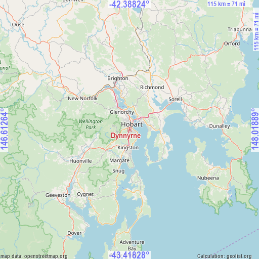
Dynnyrne GPS coordinates[2]
42° 54' 19.476" South, 147° 18' 56.736" East
| Map corner | latitude | longitude |
|---|---|---|
| Upper-left | -42.38824°, | 146.61264° |
| Center: | -42.90541°, | 147.31576° |
| Lower-right: | -43.41828°, | 148.01889° |
| Map W x H: | 114.5×114.5 km | = 71.1×71.1mi |
| max Lat: | -10.58257° ⇑99.5% North |
| Dynnyrne: | -42.90541° |
| min Lat: | ⇓0.5% South -43.31423° |
| min Long | Dynnyrne | max Long |
| 113.53327° | 147.31576° | 153.61246° |
| W 49%⇐ | ⇒51% E |
Elevation
Elevation of Dynnyrne is 139 m = 456 ft, and this is 17 m = 56 ft above average elevation for this country.
| Max E: |
1715 m = 5627 ft | 24% |
| Dynnyrne | 139 m 456 ft | |
| Avg. | 122 m = 400 ft | |
Min E: |
-2 m = -7 ft | 76% |
See also: Australia elevation on elevation.city.
Geographical zone
Dynnyrne is located in South temperate zone (between Tropic of Capricorn and the Antarctic Circle). Distance of this Southern Tropic circle is 2164.7 km =1345.1 mi to North.| Distance of | km | miles | from Dynnyrne |
|---|---|---|---|
| Equator | 4770.6 | 2964.3 | to North |
| Tropic Capricorn | 2164.7 | 1345.1 | to North |
| Antarctic Circle | 2630.5 | 1634.5 | to South |
| South Pole | 5236.4 | 3253.7 | to South |


Nearby cities:
15 places around Dynnyrne: (largest is in red/bold)
• Battery Point
2.2 km =1.4 mi,  39°
39°
• Fern Tree
4.6 km =2.9 mi,  247°
247°
• Glebe
3.6 km =2.2 mi,  16°
16°
• Hobart
3.1 km =1.9 mi, 21°
• Hobart city centre
2.6 km =1.6 mi, 18°
• Lenah Valley
5 km =3.1 mi,  318°
318°
• Mount Nelson
1.8 km =1.1 mi,  166°
166°
• Mount Stuart
3.9 km =2.4 mi,  343°
343°
• North Hobart
3.5 km =2.2 mi,  0°
0°
• Rosny
5.1 km =3.2 mi, 41°
• Sandy Bay
1.4 km =0.9 mi,  30°
30°
• South Hobart
1.3 km =0.8 mi, 336°
• Taroona
5.2 km =3.2 mi,  149°
149°
• Tolmans Hill
1.2 km =0.7 mi,  216°
216°
• West Hobart
3.3 km =2.1 mi,  347°
347°
Sources, notices
• [Note1] Compared only with cities in Australia existing in our database
• [Src1] Map data: © OpenStreetMap contributors (CC-BY-SA)
• [Src2] Other city data from geonames.org with taken over terms of usage.
• [Src3] Geographical zone / Annual Mean Temperature by Robert A. Rohde @ Wikipedia
