Željezno Polje geodata
Željezno Polje (Federation of B&H) is a populated locality; located in Bosnia and Herzegovina in Europe/Sarajevo (GMT+2) time zone. With population of 5,783 people, there are 96 cities with bigger population in this country. Compared to other cities in Bosnia and Herzegovina, 55.8% of cities are located further ↑North; 51.3% of cities are located further →East and 78.9% of cities have lower elevation than Željezno Polje. Note1


Željezno Polje GPS coordinates[2]
44° 23' 55.5" North, 17° 56' 27.708" East
| Map corner | latitude | longitude |
|---|---|---|
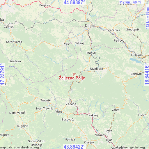
| Upper-left | 44.89897°, | 17.23791° |
| Center: | 44.39875°, | 17.94103° |
| Lower-right: | 43.89422°, | 18.64416° |
| Map W x H: | 111.7×111.7 km | = 69.4×69.4mi |
| max Lat: | 45.21956° ⇑55.8% North |
| Željezno Polje: | 44.39875° |
| min Lat: | ⇓44.2% South 42.71197° |
| min Long | Željezno Polje | max Long |
| 15.77806° | 17.94103° | 19.36719° |
| W 48.7%⇐ | ⇒51.3% E |
Elevation
Elevation of Željezno Polje is 528 m = 1732 ft, and this is 168.5 m = 553 ft above average elevation for this country.
| Max E: |
1175 m = 3855 ft | 21.1% |
| Željezno Polje | 528 m 1732 ft | |
| Avg. | 359.5 m = 1179 ft | |
Min E: |
17 m = 56 ft | 78.9% |
See also: Bosnia and Herzegovina elevation on elevation.city.
Geographical zone
Željezno Polje is located in North temperate zone (between Tropic of Cancer and the Arctic Circle). Distance of this Northern Tropic circle is 2330.8 km =1448.3 mi to South.| Distance of | km | miles | from Željezno Polje |
|---|---|---|---|
| North Pole | 5070.4 | 3150.6 | to North |
| Arctic Circle | 2464.5 | 1531.4 | to North |
| Tropic Cancer | 2330.8 | 1448.3 | to South |
| Equator | 4936.7 | 3067.5 | to South |


Nearby cities:
15 places around Željezno Polje: (largest is in red/bold)
• Blatnica
13.6 km =8.5 mi,  316°
316°
• Dubravica
14.9 km =9.3 mi,  71°
71°
• Gostovići
18.3 km =11.4 mi,  85°
85°
• Jelah
28.4 km =17.6 mi,  2°
2°
• Karadaglije
20.1 km =12.5 mi,  17°
17°
• Kovači
21.7 km =13.5 mi,  75°
75°
• Liješnica
15.2 km =9.4 mi,  45°
45°
• Lokvine
22.6 km =14 mi,  197°
197°
• Maglaj
20.8 km =12.9 mi,  37°
37°
• Novi Šeher
14.1 km =8.8 mi,  28°
28°
• Teslić
24 km =14.9 mi,  344°
344°
• Tešanj
24 km =14.9 mi,  8°
8°
• Zavidovići
17.4 km =10.8 mi, 72°
• Zenica
22.1 km =13.7 mi,  187°
187°
• Žepče
8.3 km =5.2 mi, 68°
Sources, notices
• [Note1] Compared only with cities in Bosnia and Herzegovina existing in our database
• [Src1] Map data: © OpenStreetMap contributors (CC-BY-SA)
• [Src2] Other city data from geonames.org with taken over terms of usage.
• [Src3] Geographical zone / Annual Mean Temperature by Robert A. Rohde @ Wikipedia
