Maglaj geodata
Maglaj (Federation of B&H) is a seat of a third-order administrative division; located in Bosnia and Herzegovina in Europe/Sarajevo (GMT+2) time zone. With population of 7,399 people, there are 60 cities with bigger population in this country. Compared to other cities in Bosnia and Herzegovina, 56.6% of cities are located further ↓South; 57% of cities are located further ←West and 75.1% of cities have higher elevation than Maglaj. Note1


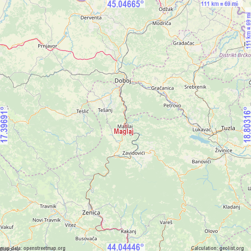
Maglaj GPS coordinates[2]
44° 32' 51.756" North, 18° 6' 0.108" East
| Map corner | latitude | longitude |
|---|---|---|
| Upper-left | 45.04665°, | 17.39691° |
| Center: | 44.54771°, | 18.10003° |
| Lower-right: | 44.04446°, | 18.80316° |
| Map W x H: | 111.4×111.4 km | = 69.2×69.2mi |
| max Lat: | 45.21956° ⇑43.4% North |
| Maglaj: | 44.54771° |
| min Lat: | ⇓56.6% South 42.71197° |
| min Long | Maglaj | max Long |
| 15.77806° | 18.10003° | 19.36719° |
| W 57%⇐ | ⇒43% E |
Elevation
Elevation of Maglaj is 177 m = 581 ft, and this is 182.5 m = 599 ft below average elevation for this country.
| Max E: |
1175 m = 3855 ft | 75.1% |
| Avg. | 359.5 m = 1179 ft | |
| Maglaj | 177 m = 581 ft | |
Min E: |
17 m = 56 ft | 24.9% |
See also: Bosnia and Herzegovina elevation on elevation.city.
Geographical zone
Maglaj is located in North temperate zone (between Tropic of Cancer and the Arctic Circle). Distance of this Northern Tropic circle is 2347.3 km =1458.5 mi to South.| Distance of | km | miles | from Maglaj |
|---|---|---|---|
| North Pole | 5053.8 | 3140.3 | to North |
| Arctic Circle | 2447.9 | 1521.1 | to North |
| Tropic Cancer | 2347.3 | 1458.5 | to South |
| Equator | 4953.2 | 3077.8 | to South |


Nearby cities:
15 places around Maglaj: (largest is in red/bold)
• Doboj
20.5 km =12.7 mi,  357°
357°
• Dubravica
11.9 km =7.4 mi,  172°
172°
• Gostovići
16.2 km =10.1 mi,  159°
159°
• Jelah
16.3 km =10.1 mi,  316°
316°
• Karadaglije
7 km =4.3 mi,  291°
291°
• Kovači
13.8 km =8.6 mi,  142°
142°
• Liješnica
6.2 km =3.9 mi,  197°
197°
• Matuzići
16.1 km =10 mi,  345°
345°
• Novi Šeher
7.2 km =4.5 mi,  234°
234°
• Omanjska
20.2 km =12.6 mi,  326°
326°
• Teslić
20.1 km =12.5 mi, 288°
• Tešanj
11.5 km =7.1 mi,  308°
308°
• Tešanjka
15.5 km =9.6 mi, 333°
• Zavidovići
12 km =7.5 mi, 160°
• Žepče
14.3 km =8.9 mi, 200°
Sources, notices
• [Note1] Compared only with cities in Bosnia and Herzegovina existing in our database
• [Src1] Map data: © OpenStreetMap contributors (CC-BY-SA)
• [Src2] Other city data from geonames.org with taken over terms of usage.
• [Src3] Geographical zone / Annual Mean Temperature by Robert A. Rohde @ Wikipedia
