Prijedor geodata
Prijedor (Srpska) is a seat of a second-order administrative division; located in Bosnia and Herzegovina in Europe/Sarajevo (GMT+2) time zone. With population of 36,347 people, there are 9 cities with bigger population in this country. Compared to other cities in Bosnia and Herzegovina, 87.9% of cities are located further ↓South; 85.3% of cities are located further →East and 83.8% of cities have higher elevation than Prijedor. Note1


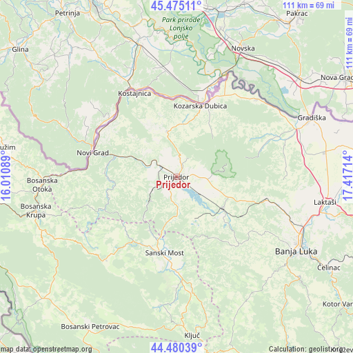
Prijedor GPS coordinates[2]
44° 58' 47.676" North, 16° 42' 50.436" East
| Map corner | latitude | longitude |
|---|---|---|
| Upper-left | 45.47511°, | 16.01089° |
| Center: | 44.97991°, | 16.71401° |
| Lower-right: | 44.48039°, | 17.41714° |
| Map W x H: | 110.6×110.6 km | = 68.7×68.7mi |
| max Lat: | 45.21956° ⇑12.1% North |
| Prijedor: | 44.97991° |
| min Lat: | ⇓87.9% South 42.71197° |
| min Long | Prijedor | max Long |
| 15.77806° | 16.71401° | 19.36719° |
| W 14.7%⇐ | ⇒85.3% E |
Elevation
Elevation of Prijedor is 140 m = 459 ft, and this is 219.5 m = 720 ft below average elevation for this country.
| Max E: |
1175 m = 3855 ft | 83.8% |
| Avg. | 359.5 m = 1179 ft | |
| Prijedor | 140 m = 459 ft | |
Min E: |
17 m = 56 ft | 16.2% |
See also: Bosnia and Herzegovina elevation on elevation.city.
Geographical zone
Prijedor is located in North temperate zone (between Tropic of Cancer and the Arctic Circle). Distance of this Northern Tropic circle is 2395.4 km =1488.4 mi to South.| Distance of | km | miles | from Prijedor |
|---|---|---|---|
| North Pole | 5005.8 | 3110.5 | to North |
| Arctic Circle | 2399.9 | 1491.2 | to North |
| Tropic Cancer | 2395.4 | 1488.4 | to South |
| Equator | 5001.3 | 3107.7 | to South |


Nearby cities:
15 places around Prijedor: (largest is in red/bold)
• Bronzani Majdan
27.4 km =17 mi,  139°
139°
• Dobrljin
26.5 km =16.5 mi,  315°
315°
• Donji Dubovik
32.2 km =20 mi,  251°
251°
• Knežica
14.3 km =8.9 mi,  348°
348°
• Kostajnica
30 km =18.6 mi,  332°
332°
• Kozarska Dubica
23.1 km =14.4 mi,  18°
18°
• Lamovita
16 km =9.9 mi,  114°
114°
• Marićka
16.7 km =10.4 mi, 138°
• Novi Grad
27.4 km =17 mi,  285°
285°
• Omarska
17.5 km =10.9 mi,  124°
124°
• Oštra Luka
13.9 km =8.6 mi,  197°
197°
• Peći
39.1 km =24.3 mi,  172°
172°
• Piskavica
24 km =14.9 mi, 121°
• Sanski Most
24 km =14.9 mi,  188°
188°
• Svodna
15.1 km =9.4 mi,  295°
295°
Sources, notices
• [Note1] Compared only with cities in Bosnia and Herzegovina existing in our database
• [Src1] Map data: © OpenStreetMap contributors (CC-BY-SA)
• [Src2] Other city data from geonames.org with taken over terms of usage.
• [Src3] Geographical zone / Annual Mean Temperature by Robert A. Rohde @ Wikipedia
