Sanski Most geodata
Sanski Most (Federation of B&H) is a seat of a third-order administrative division; located in Bosnia and Herzegovina in Europe/Sarajevo (GMT+2) time zone. With population of 13,551 people, there are 25 cities with bigger population in this country. Compared to other cities in Bosnia and Herzegovina, 74.3% of cities are located further ↓South; 86% of cities are located further →East and 80% of cities have higher elevation than Sanski Most. Note1


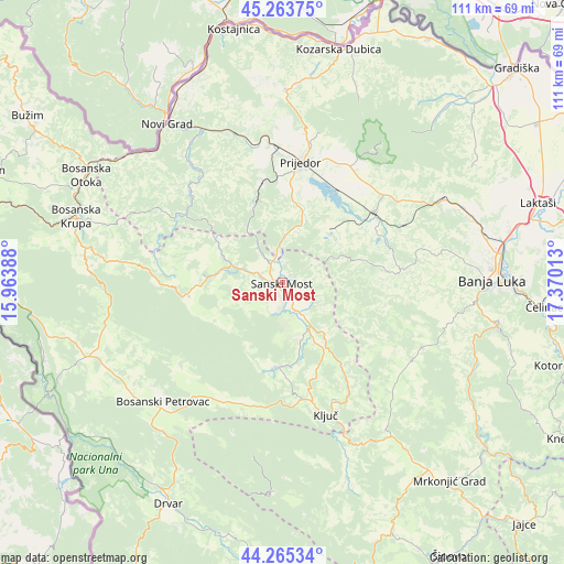
Sanski Most GPS coordinates[2]
44° 46' 0.12" North, 16° 40' 1.2" East
| Map corner | latitude | longitude |
|---|---|---|
| Upper-left | 45.26375°, | 15.96388° |
| Center: | 44.7667°, | 16.667° |
| Lower-right: | 44.26534°, | 17.37013° |
| Map W x H: | 111×111 km | = 69×69mi |
| max Lat: | 45.21956° ⇑25.7% North |
| Sanski Most: | 44.7667° |
| min Lat: | ⇓74.3% South 42.71197° |
| min Long | Sanski Most | max Long |
| 15.77806° | 16.667° | 19.36719° |
| W 14%⇐ | ⇒86% E |
Elevation
Elevation of Sanski Most is 158 m = 518 ft, and this is 201.5 m = 661 ft below average elevation for this country.
| Max E: |
1175 m = 3855 ft | 80% |
| Avg. | 359.5 m = 1179 ft | |
| Sanski Most | 158 m = 518 ft | |
Min E: |
17 m = 56 ft | 20% |
See also: Bosnia and Herzegovina elevation on elevation.city.
Geographical zone
Sanski Most is located in North temperate zone (between Tropic of Cancer and the Arctic Circle). Distance of this Northern Tropic circle is 2371.7 km =1473.7 mi to South.| Distance of | km | miles | from Sanski Most |
|---|---|---|---|
| North Pole | 5029.5 | 3125.2 | to North |
| Arctic Circle | 2423.6 | 1506 | to North |
| Tropic Cancer | 2371.7 | 1473.7 | to South |
| Equator | 4977.6 | 3092.9 | to South |


Nearby cities:
15 places around Sanski Most: (largest is in red/bold)
• Bosanski Petrovac
33.3 km =20.7 mi,  225°
225°
• Bronzani Majdan
21.8 km =13.5 mi,  82°
82°
• Donji Dubovik
30.3 km =18.8 mi,  296°
296°
• Drinić
33 km =20.5 mi,  208°
208°
• Ključ
27.5 km =17.1 mi,  161°
161°
• Lamovita
25 km =15.5 mi,  47°
47°
• Marićka
18.6 km =11.6 mi, 52°
• Omarska
22.9 km =14.2 mi, 52°
• Oštra Luka
10.4 km =6.5 mi,  357°
357°
• Peći
17.6 km =10.9 mi,  148°
148°
• Piskavica
26.7 km =16.6 mi,  65°
65°
• Prijedor
24 km =14.9 mi,  8°
8°
• Sanica
17.2 km =10.7 mi,  186°
186°
• Svodna
31.7 km =19.7 mi,  341°
341°
• Velagići
24 km =14.9 mi,  167°
167°
Sources, notices
• [Note1] Compared only with cities in Bosnia and Herzegovina existing in our database
• [Src1] Map data: © OpenStreetMap contributors (CC-BY-SA)
• [Src2] Other city data from geonames.org with taken over terms of usage.
• [Src3] Geographical zone / Annual Mean Temperature by Robert A. Rohde @ Wikipedia
