Mostar geodata
Mostar (Federation of B&H) is a seat of a second-order administrative division; located in Bosnia and Herzegovina in Europe/Sarajevo (GMT+2) time zone. With population of 104,518 people, there are 4 cities with bigger population in this country. Compared to other cities in Bosnia and Herzegovina, 93.2% of cities are located further ↑North; 56.6% of cities are located further →East and 98.1% of cities have higher elevation than Mostar. Note1


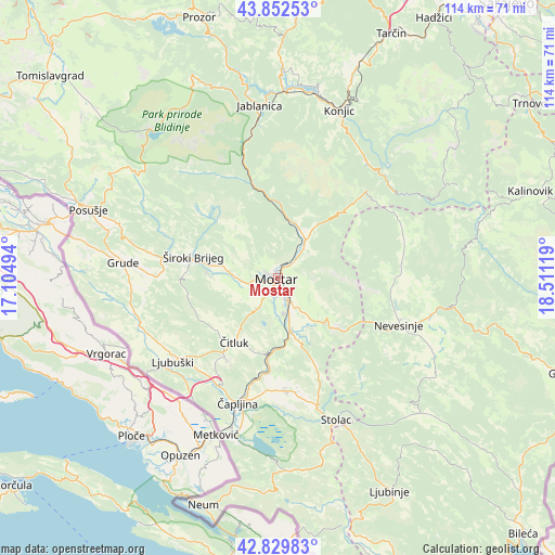
Mostar GPS coordinates[2]
43° 20' 35.988" North, 17° 48' 29.016" East
| Map corner | latitude | longitude |
|---|---|---|
| Upper-left | 43.85253°, | 17.10494° |
| Center: | 43.34333°, | 17.80806° |
| Lower-right: | 42.82983°, | 18.51119° |
| Map W x H: | 113.7×113.7 km | = 70.6×70.6mi |
| max Lat: | 45.21956° ⇑93.2% North |
| Mostar: | 43.34333° |
| min Lat: | ⇓6.8% South 42.71197° |
| min Long | Mostar | max Long |
| 15.77806° | 17.80806° | 19.36719° |
| W 43.4%⇐ | ⇒56.6% E |
Elevation
Elevation of Mostar is 66 m = 217 ft, and this is 293.5 m = 963 ft below average elevation for this country.
| Max E: |
1175 m = 3855 ft | 98.1% |
| Avg. | 359.5 m = 1179 ft | |
| Mostar | 66 m = 217 ft | |
Min E: |
17 m = 56 ft | 1.9% |
See also: Mostar elevation on elevation.city.
Geographical zone
Mostar is located in North temperate zone (between Tropic of Cancer and the Arctic Circle). Distance of this Northern Tropic circle is 2213.4 km =1375.3 mi to South.| Distance of | km | miles | from Mostar |
|---|---|---|---|
| North Pole | 5187.7 | 3223.5 | to North |
| Arctic Circle | 2581.8 | 1604.3 | to North |
| Tropic Cancer | 2213.4 | 1375.3 | to South |
| Equator | 4819.3 | 2994.6 | to South |


Nearby cities:
15 places around Mostar: (largest is in red/bold)
• Blagaj
11.4 km =7.1 mi,  145°
145°
• Cim
2.5 km =1.6 mi,  298°
298°
• Crnići
24 km =14.9 mi,  169°
169°
• Ilići
3.2 km =2 mi,  278°
278°
• Kočerin
26.6 km =16.5 mi, 281°
• Ljubuški
26.8 km =16.7 mi,  232°
232°
• Nevesinje
26.4 km =16.4 mi,  110°
110°
• Potoci
9.3 km =5.8 mi,  37°
37°
• Radišići
25.5 km =15.8 mi,  238°
238°
• Rodoč
3.2 km =2 mi,  187°
187°
• Tasovčići
26.6 km =16.5 mi,  195°
195°
• Vitina
28.8 km =17.9 mi,  245°
245°
• Čapljina
26.6 km =16.5 mi, 202°
• Čitluk
15.4 km =9.6 mi,  214°
214°
• Široki Brijeg
17.8 km =11.1 mi, 284°
Sources, notices
• [Note1] Compared only with cities in Bosnia and Herzegovina existing in our database
• [Src1] Map data: © OpenStreetMap contributors (CC-BY-SA)
• [Src2] Other city data from geonames.org with taken over terms of usage.
• [Src3] Geographical zone / Annual Mean Temperature by Robert A. Rohde @ Wikipedia
