Čitluk geodata
Čitluk (Federation of B&H) is a seat of a third-order administrative division; located in Bosnia and Herzegovina in Europe/Sarajevo (GMT+2) time zone. With population of 5,718 people, there are 97 cities with bigger population in this country. Compared to other cities in Bosnia and Herzegovina, 95.1% of cities are located further ↑North; 59.6% of cities are located further →East and 63% of cities have higher elevation than Čitluk. Note1


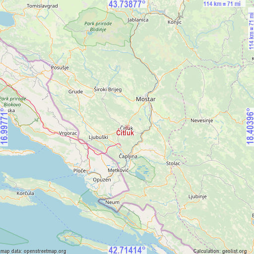
Čitluk GPS coordinates[2]
43° 13' 42.996" North, 17° 42' 2.988" East
| Map corner | latitude | longitude |
|---|---|---|
| Upper-left | 43.73877°, | 16.99771° |
| Center: | 43.22861°, | 17.70083° |
| Lower-right: | 42.71414°, | 18.40396° |
| Map W x H: | 113.9×113.9 km | = 70.8×70.8mi |
| max Lat: | 45.21956° ⇑95.1% North |
| Čitluk: | 43.22861° |
| min Lat: | ⇓4.9% South 42.71197° |
| min Long | Čitluk | max Long |
| 15.77806° | 17.70083° | 19.36719° |
| W 40.4%⇐ | ⇒59.6% E |
Elevation
Elevation of Čitluk is 225 m = 738 ft, and this is 134.5 m = 441 ft below average elevation for this country.
| Max E: |
1175 m = 3855 ft | 63% |
| Avg. | 359.5 m = 1179 ft | |
| Čitluk | 225 m = 738 ft | |
Min E: |
17 m = 56 ft | 37% |
See also: Bosnia and Herzegovina elevation on elevation.city.
Geographical zone
Čitluk is located in North temperate zone (between Tropic of Cancer and the Arctic Circle). Distance of this Northern Tropic circle is 2200.7 km =1367.5 mi to South.| Distance of | km | miles | from Čitluk |
|---|---|---|---|
| North Pole | 5200.5 | 3231.4 | to North |
| Arctic Circle | 2594.6 | 1612.2 | to North |
| Tropic Cancer | 2200.7 | 1367.5 | to South |
| Equator | 4806.6 | 2986.7 | to South |


Nearby cities:
15 places around Čitluk: (largest is in red/bold)
• Blagaj
15.5 km =9.6 mi,  77°
77°
• Cim
15.4 km =9.6 mi,  24°
24°
• Crnići
17.1 km =10.6 mi,  129°
129°
• Ilići
14.3 km =8.9 mi, 22°
• Kočerin
25 km =15.5 mi,  315°
315°
• Ljubuški
13.1 km =8.1 mi,  254°
254°
• Mostar
15.4 km =9.6 mi,  34°
34°
• Potoci
24.7 km =15.3 mi,  35°
35°
• Radišići
13 km =8.1 mi,  267°
267°
• Rodoč
12.6 km =7.8 mi, 40°
• Stolac
26.5 km =16.5 mi, 127°
• Tasovčići
12.9 km =8 mi,  173°
173°
• Vitina
17.6 km =10.9 mi, 273°
• Čapljina
12 km =7.5 mi,  186°
186°
• Široki Brijeg
19.2 km =11.9 mi,  333°
333°
Sources, notices
• [Note1] Compared only with cities in Bosnia and Herzegovina existing in our database
• [Src1] Map data: © OpenStreetMap contributors (CC-BY-SA)
• [Src2] Other city data from geonames.org with taken over terms of usage.
• [Src3] Geographical zone / Annual Mean Temperature by Robert A. Rohde @ Wikipedia
