Maslovare geodata
Maslovare (Srpska) is a populated place; located in Bosnia and Herzegovina in Europe/Sarajevo (GMT+2) time zone. With population of 4,899 people, there are 120 cities with bigger population in this country. Compared to other cities in Bosnia and Herzegovina, 58.5% of cities are located further ↓South; 64.9% of cities are located further →East and 68.3% of cities have lower elevation than Maslovare. Note1


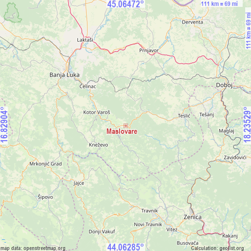
Maslovare GPS coordinates[2]
44° 33' 57.384" North, 17° 31' 55.776" East
| Map corner | latitude | longitude |
|---|---|---|
| Upper-left | 45.06472°, | 16.82904° |
| Center: | 44.56594°, | 17.53216° |
| Lower-right: | 44.06285°, | 18.23529° |
| Map W x H: | 111.4×111.4 km | = 69.2×69.2mi |
| max Lat: | 45.21956° ⇑41.5% North |
| Maslovare: | 44.56594° |
| min Lat: | ⇓58.5% South 42.71197° |
| min Long | Maslovare | max Long |
| 15.77806° | 17.53216° | 19.36719° |
| W 35.1%⇐ | ⇒64.9% E |
Elevation
Elevation of Maslovare is 401 m = 1316 ft, and this is 41.5 m = 136 ft above average elevation for this country.
| Max E: |
1175 m = 3855 ft | 31.7% |
| Maslovare | 401 m 1316 ft | |
| Avg. | 359.5 m = 1179 ft | |
Min E: |
17 m = 56 ft | 68.3% |
See also: Bosnia and Herzegovina elevation on elevation.city.
Geographical zone
Maslovare is located in North temperate zone (between Tropic of Cancer and the Arctic Circle). Distance of this Northern Tropic circle is 2349.3 km =1459.8 mi to South.| Distance of | km | miles | from Maslovare |
|---|---|---|---|
| North Pole | 5051.8 | 3139 | to North |
| Arctic Circle | 2445.9 | 1519.8 | to North |
| Tropic Cancer | 2349.3 | 1459.8 | to South |
| Equator | 4955.3 | 3079.1 | to South |


Nearby cities:
15 places around Maslovare: (largest is in red/bold)
• Blatnica
24.7 km =15.3 mi,  110°
110°
• Divičani
27.5 km =17.1 mi,  216°
216°
• Dobratići
22.9 km =14.2 mi,  204°
204°
• Jajce
32.4 km =20.1 mi, 219°
• Kneževo
14.6 km =9.1 mi,  234°
234°
• Kotor Varoš
14 km =8.7 mi,  294°
294°
• Krupa na Vrbasu
31.3 km =19.4 mi,  280°
280°
• Pribinić
13.4 km =8.3 mi,  68°
68°
• Stanari
30.7 km =19.1 mi,  49°
49°
• Starcevica
33.1 km =20.6 mi,  309°
309°
• Teslić
26.3 km =16.3 mi,  80°
80°
• Čelinac
24.1 km =15 mi,  317°
317°
• Čelinac
25.7 km =16 mi, 318°
• Čečava
21.9 km =13.6 mi, 54°
• Živinice
12.7 km =7.9 mi,  260°
260°
Sources, notices
• [Note1] Compared only with cities in Bosnia and Herzegovina existing in our database
• [Src1] Map data: © OpenStreetMap contributors (CC-BY-SA)
• [Src2] Other city data from geonames.org with taken over terms of usage.
• [Src3] Geographical zone / Annual Mean Temperature by Robert A. Rohde @ Wikipedia
