Kotor Varoš geodata
Kotor Varoš (Srpska) is a seat of a second-order administrative division; located in Bosnia and Herzegovina in Europe/Sarajevo (GMT+2) time zone. With population of 5,068 people, there are 111 cities with bigger population in this country. Compared to other cities in Bosnia and Herzegovina, 61.9% of cities are located further ↓South; 69.4% of cities are located further →East and 52.8% of cities have higher elevation than Kotor Varoš. Note1


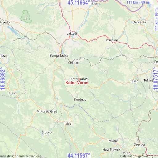
Kotor Varoš GPS coordinates[2]
44° 37' 5.916" North, 17° 22' 19.344" East
| Map corner | latitude | longitude |
|---|---|---|
| Upper-left | 45.11664°, | 16.66892° |
| Center: | 44.61831°, | 17.37204° |
| Lower-right: | 44.11567°, | 18.07517° |
| Map W x H: | 111.3×111.3 km | = 69.2×69.2mi |
| max Lat: | 45.21956° ⇑38.1% North |
| Kotor Varoš: | 44.61831° |
| min Lat: | ⇓61.9% South 42.71197° |
| min Long | Kotor Varoš | max Long |
| 15.77806° | 17.37204° | 19.36719° |
| W 30.6%⇐ | ⇒69.4% E |
Elevation
Elevation of Kotor Varoš is 281 m = 922 ft, and this is 78.5 m = 258 ft below average elevation for this country.
| Max E: |
1175 m = 3855 ft | 52.8% |
| Avg. | 359.5 m = 1179 ft | |
| Kotor Varoš | 281 m = 922 ft | |
Min E: |
17 m = 56 ft | 47.2% |
See also: Bosnia and Herzegovina elevation on elevation.city.
Geographical zone
Kotor Varoš is located in North temperate zone (between Tropic of Cancer and the Arctic Circle). Distance of this Northern Tropic circle is 2355.2 km =1463.5 mi to South.| Distance of | km | miles | from Kotor Varoš |
|---|---|---|---|
| North Pole | 5046 | 3135.4 | to North |
| Arctic Circle | 2440.1 | 1516.2 | to North |
| Tropic Cancer | 2355.2 | 1463.5 | to South |
| Equator | 4961.1 | 3082.7 | to South |


Nearby cities:
15 places around Kotor Varoš: (largest is in red/bold)
• Banja Luka
22.7 km =14.1 mi,  321°
321°
• Divičani
28.2 km =17.5 mi,  187°
187°
• Dobratići
26.9 km =16.7 mi,  172°
172°
• Hiseti
22 km =13.7 mi, 316°
• Kneževo
14.2 km =8.8 mi,  176°
176°
• Krupa na Vrbasu
18.1 km =11.2 mi,  270°
270°
• Maslovare
14 km =8.7 mi,  114°
114°
• Mejdan - Obilićevo
21.6 km =13.4 mi, 318°
• Pribinić
25.2 km =15.7 mi,  92°
92°
• Starcevica
20 km =12.4 mi, 320°
• Trn
28.8 km =17.9 mi,  338°
338°
• Čelinac
12.4 km =7.7 mi, 342°
• Čelinac
14.2 km =8.8 mi, 342°
• Čečava
31.3 km =19.4 mi,  77°
77°
• Živinice
7.9 km =4.9 mi, 179°
Sources, notices
• [Note1] Compared only with cities in Bosnia and Herzegovina existing in our database
• [Src1] Map data: © OpenStreetMap contributors (CC-BY-SA)
• [Src2] Other city data from geonames.org with taken over terms of usage.
• [Src3] Geographical zone / Annual Mean Temperature by Robert A. Rohde @ Wikipedia
