Kupres geodata
Kupres (Federation of B&H) is a seat of a third-order administrative division; located in Bosnia and Herzegovina in Europe/Sarajevo (GMT+2) time zone. In our database, there are 234 cities with bigger population. Compared to other cities in Bosnia and Herzegovina, 71.3% of cities are located further ↑North; 73.2% of cities are located further →East and 100% of cities have lower elevation than Kupres. Note1


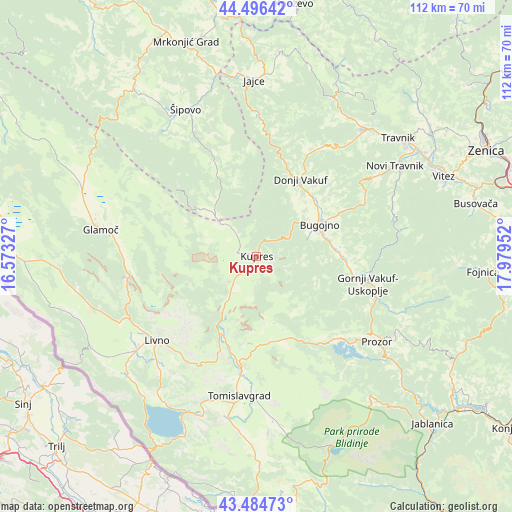
Kupres GPS coordinates[2]
43° 59' 33.828" North, 17° 16' 35.004" East
| Map corner | latitude | longitude |
|---|---|---|
| Upper-left | 44.49642°, | 16.57327° |
| Center: | 43.99273°, | 17.27639° |
| Lower-right: | 43.48473°, | 17.97952° |
| Map W x H: | 112.5×112.5 km | = 69.9×69.9mi |
| max Lat: | 45.21956° ⇑71.3% North |
| Kupres: | 43.99273° |
| min Lat: | ⇓28.7% South 42.71197° |
| min Long | Kupres | max Long |
| 15.77806° | 17.27639° | 19.36719° |
| W 26.8%⇐ | ⇒73.2% E |
Elevation
Elevation of Kupres is 1175 m = 3855 ft, and this is 815.5 m = 2676 ft above average elevation for this country.
| Max E: |
1175 m = 3855 ft | 0% |
| Kupres | 1175 m 3855 ft | |
| Avg. | 359.5 m = 1179 ft | |
Min E: |
17 m = 56 ft | 100% |
See also: Bosnia and Herzegovina elevation on elevation.city.
Geographical zone
Kupres is located in North temperate zone (between Tropic of Cancer and the Arctic Circle). Distance of this Northern Tropic circle is 2285.6 km =1420.2 mi to South.| Distance of | km | miles | from Kupres |
|---|---|---|---|
| North Pole | 5115.5 | 3178.6 | to North |
| Arctic Circle | 2509.6 | 1559.4 | to North |
| Tropic Cancer | 2285.6 | 1420.2 | to South |
| Equator | 4891.5 | 3039.4 | to South |


Nearby cities:
15 places around Kupres: (largest is in red/bold)
• Bugojno
15.7 km =9.8 mi,  62°
62°
• Donji Vakuf
19.5 km =12.1 mi,  30°
30°
• Glamoč
34.7 km =21.6 mi,  279°
279°
• Gornji Vakuf
25.7 km =16 mi,  103°
103°
• Livno
28.4 km =17.6 mi,  229°
229°
• Novi Travnik
36.4 km =22.6 mi, 56°
• Novo Selo
13.7 km =8.5 mi,  315°
315°
• Pajić Polje
20.2 km =12.6 mi, 95°
• Prozor
32.7 km =20.3 mi,  125°
125°
• Rumboci
25.5 km =15.8 mi, 134°
• Tomislavgrad
30.8 km =19.1 mi,  187°
187°
• Vidoši
31.6 km =19.6 mi,  218°
218°
• Voljevac
33.1 km =20.6 mi,  112°
112°
• Zabrišće
34.8 km =21.6 mi, 230°
• Šipovo
35.6 km =22.1 mi,  334°
334°
Sources, notices
• [Note1] Compared only with cities in Bosnia and Herzegovina existing in our database
• [Src1] Map data: © OpenStreetMap contributors (CC-BY-SA)
• [Src2] Other city data from geonames.org with taken over terms of usage.
• [Src3] Geographical zone / Annual Mean Temperature by Robert A. Rohde @ Wikipedia
