Bugojno geodata
Bugojno (Federation of B&H) is a seat of a third-order administrative division; located in Bosnia and Herzegovina in Europe/Sarajevo (GMT+2) time zone. With population of 41,378 people, there are 6 cities with bigger population in this country. Compared to other cities in Bosnia and Herzegovina, 68.7% of cities are located further ↑North; 67.2% of cities are located further →East and 81.1% of cities have lower elevation than Bugojno. Note1


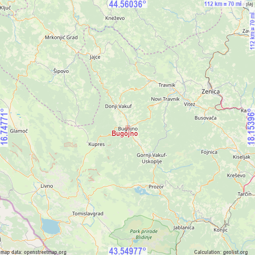
Bugojno GPS coordinates[2]
44° 3' 25.992" North, 17° 27' 2.988" East
| Map corner | latitude | longitude |
|---|---|---|
| Upper-left | 44.56036°, | 16.74771° |
| Center: | 44.05722°, | 17.45083° |
| Lower-right: | 43.54977°, | 18.15396° |
| Map W x H: | 112.4×112.4 km | = 69.8×69.8mi |
| max Lat: | 45.21956° ⇑68.7% North |
| Bugojno: | 44.05722° |
| min Lat: | ⇓31.3% South 42.71197° |
| min Long | Bugojno | max Long |
| 15.77806° | 17.45083° | 19.36719° |
| W 32.8%⇐ | ⇒67.2% E |
Elevation
Elevation of Bugojno is 565 m = 1854 ft, and this is 205.5 m = 674 ft above average elevation for this country.
| Max E: |
1175 m = 3855 ft | 18.9% |
| Bugojno | 565 m 1854 ft | |
| Avg. | 359.5 m = 1179 ft | |
Min E: |
17 m = 56 ft | 81.1% |
See also: Bugojno elevation on elevation.city.
Geographical zone
Bugojno is located in North temperate zone (between Tropic of Cancer and the Arctic Circle). Distance of this Northern Tropic circle is 2292.8 km =1424.7 mi to South.| Distance of | km | miles | from Bugojno |
|---|---|---|---|
| North Pole | 5108.4 | 3174.2 | to North |
| Arctic Circle | 2502.5 | 1555 | to North |
| Tropic Cancer | 2292.8 | 1424.7 | to South |
| Equator | 4898.7 | 3043.9 | to South |


Nearby cities:
15 places around Bugojno: (largest is in red/bold)
• Busovača
34.4 km =21.4 mi,  82°
82°
• Divičani
35.8 km =22.2 mi,  343°
343°
• Donji Vakuf
10.4 km =6.5 mi, 337°
• Gornji Vakuf
17.2 km =10.7 mi,  140°
140°
• Jajce
34.8 km =21.6 mi, 335°
• Kupres
15.7 km =9.8 mi,  242°
242°
• Novi Travnik
20.9 km =13 mi,  52°
52°
• Novo Selo
23.7 km =14.7 mi,  276°
276°
• Pajić Polje
10.9 km =6.8 mi,  145°
145°
• Prozor
29 km =18 mi, 154°
• Rumboci
25.4 km =15.8 mi,  170°
170°
• Travnik
25.5 km =15.8 mi,  42°
42°
• Turbe
23 km =14.3 mi,  25°
25°
• Vitez
29.2 km =18.1 mi,  68°
68°
• Voljevac
25.9 km =16.1 mi, 140°
Sources, notices
• [Note1] Compared only with cities in Bosnia and Herzegovina existing in our database
• [Src1] Map data: © OpenStreetMap contributors (CC-BY-SA)
• [Src2] Other city data from geonames.org with taken over terms of usage.
• [Src3] Geographical zone / Annual Mean Temperature by Robert A. Rohde @ Wikipedia
