Kreševo geodata
Kreševo (Federation of B&H) is a seat of a third-order administrative division; located in Bosnia and Herzegovina in Europe/Sarajevo (GMT+2) time zone. In our database, there are 234 cities with bigger population. Compared to other cities in Bosnia and Herzegovina, 77% of cities are located further ↑North; 54% of cities are located further ←West and 84.5% of cities have lower elevation than Kreševo. Note1


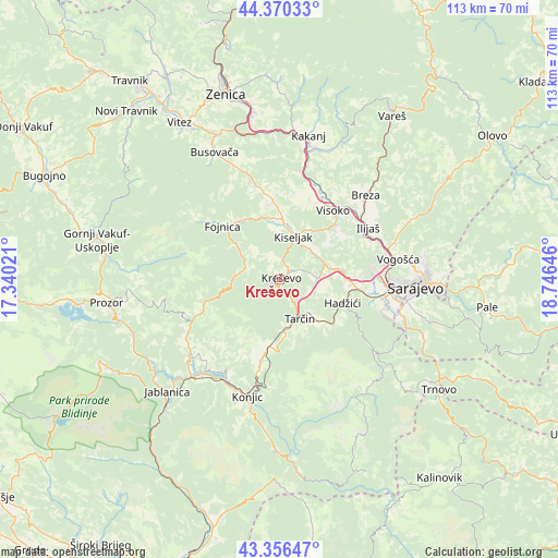
Kreševo GPS coordinates[2]
43° 51' 56.016" North, 18° 2' 35.988" East
| Map corner | latitude | longitude |
|---|---|---|
| Upper-left | 44.37033°, | 17.34021° |
| Center: | 43.86556°, | 18.04333° |
| Lower-right: | 43.35647°, | 18.74646° |
| Map W x H: | 112.7×112.7 km | = 70×70mi |
| max Lat: | 45.21956° ⇑77% North |
| Kreševo: | 43.86556° |
| min Lat: | ⇓23% South 42.71197° |
| min Long | Kreševo | max Long |
| 15.77806° | 18.04333° | 19.36719° |
| W 54%⇐ | ⇒46% E |
Elevation
Elevation of Kreševo is 607 m = 1991 ft, and this is 247.5 m = 812 ft above average elevation for this country.
| Max E: |
1175 m = 3855 ft | 15.5% |
| Kreševo | 607 m 1991 ft | |
| Avg. | 359.5 m = 1179 ft | |
Min E: |
17 m = 56 ft | 84.5% |
See also: Bosnia and Herzegovina elevation on elevation.city.
Geographical zone
Kreševo is located in North temperate zone (between Tropic of Cancer and the Arctic Circle). Distance of this Northern Tropic circle is 2271.5 km =1411.4 mi to South.| Distance of | km | miles | from Kreševo |
|---|---|---|---|
| North Pole | 5129.7 | 3187.4 | to North |
| Arctic Circle | 2523.8 | 1568.2 | to North |
| Tropic Cancer | 2271.5 | 1411.4 | to South |
| Equator | 4877.4 | 3030.7 | to South |


Nearby cities:
15 places around Kreševo: (largest is in red/bold)
• Breza
24.3 km =15.1 mi,  45°
45°
• Dobrinje
21.4 km =13.3 mi,  16°
16°
• Fojnica
15.4 km =9.6 mi,  312°
312°
• Gornje Moštre
19.3 km =12 mi,  27°
27°
• Gračanica
24.2 km =15 mi,  127°
127°
• Gromiljak
11.3 km =7 mi,  4°
4°
• Hadžići
14 km =8.7 mi,  110°
110°
• Ilidža
21 km =13 mi,  101°
101°
• Ilijaš
20.6 km =12.8 mi,  62°
62°
• Kačuni
23.6 km =14.7 mi,  339°
339°
• Kiseljak
9.1 km =5.7 mi, 19°
• Mahala
23.5 km =14.6 mi, 46°
• Pazarić
12.7 km =7.9 mi, 132°
• Polje
3 km =1.9 mi, 57°
• Visoko
17.4 km =10.8 mi,  38°
38°
Sources, notices
• [Note1] Compared only with cities in Bosnia and Herzegovina existing in our database
• [Src1] Map data: © OpenStreetMap contributors (CC-BY-SA)
• [Src2] Other city data from geonames.org with taken over terms of usage.
• [Src3] Geographical zone / Annual Mean Temperature by Robert A. Rohde @ Wikipedia
