Mahala geodata
Mahala (Federation of B&H) is a populated place; located in Bosnia and Herzegovina in Europe/Sarajevo (GMT+2) time zone. With population of 5,062 people, there are 112 cities with bigger population in this country. Compared to other cities in Bosnia and Herzegovina, 70.9% of cities are located further ↑North; 63% of cities are located further ←West and 75.5% of cities have lower elevation than Mahala. Note1


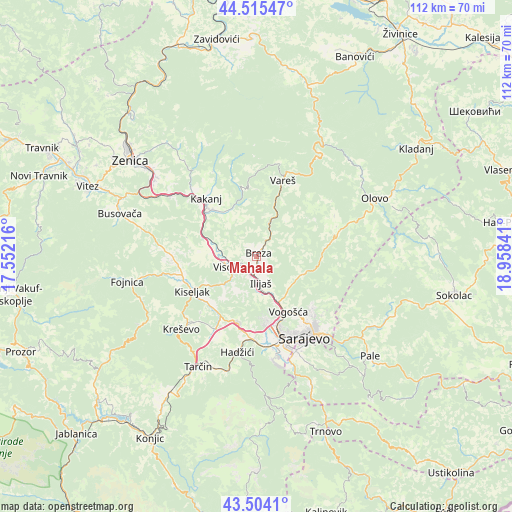
Mahala GPS coordinates[2]
44° 0' 42.984" North, 18° 15' 19.008" East
| Map corner | latitude | longitude |
|---|---|---|
| Upper-left | 44.51547°, | 17.55216° |
| Center: | 44.01194°, | 18.25528° |
| Lower-right: | 43.5041°, | 18.95841° |
| Map W x H: | 112.5×112.5 km | = 69.9×69.9mi |
| max Lat: | 45.21956° ⇑70.9% North |
| Mahala: | 44.01194° |
| min Lat: | ⇓29.1% South 42.71197° |
| min Long | Mahala | max Long |
| 15.77806° | 18.25528° | 19.36719° |
| W 63%⇐ | ⇒37% E |
Elevation
Elevation of Mahala is 485 m = 1591 ft, and this is 125.5 m = 412 ft above average elevation for this country.
| Max E: |
1175 m = 3855 ft | 24.5% |
| Mahala | 485 m 1591 ft | |
| Avg. | 359.5 m = 1179 ft | |
Min E: |
17 m = 56 ft | 75.5% |
See also: Bosnia and Herzegovina elevation on elevation.city.
Geographical zone
Mahala is located in North temperate zone (between Tropic of Cancer and the Arctic Circle). Distance of this Northern Tropic circle is 2287.8 km =1421.6 mi to South.| Distance of | km | miles | from Mahala |
|---|---|---|---|
| North Pole | 5113.4 | 3177.3 | to North |
| Arctic Circle | 2507.5 | 1558.1 | to North |
| Tropic Cancer | 2287.8 | 1421.6 | to South |
| Equator | 4893.7 | 3040.8 | to South |


Nearby cities:
15 places around Mahala: (largest is in red/bold)
• Breza
0.9 km =0.6 mi,  29°
29°
• Dobrinje
11.6 km =7.2 mi,  291°
291°
• Gornja Breza
3 km =1.9 mi,  344°
344°
• Gornje Moštre
8.1 km =5 mi,  275°
275°
• Gromiljak
16.8 km =10.4 mi,  252°
252°
• Hotonj
16.4 km =10.2 mi,  143°
143°
• Ilidža
20.6 km =12.8 mi,  169°
169°
• Ilijaš
6.9 km =4.3 mi, 169°
• Kakanj
17.1 km =10.6 mi,  321°
321°
• Kiseljak
15.9 km =9.9 mi,  241°
241°
• Kobilja Glava
18 km =11.2 mi, 143°
• Sarajevo
19.9 km =12.4 mi,  155°
155°
• Vareš
17.9 km =11.1 mi,  18°
18°
• Visoko
6.7 km =4.2 mi, 247°
• Vogošća
14.1 km =8.8 mi,  149°
149°
Sources, notices
• [Note1] Compared only with cities in Bosnia and Herzegovina existing in our database
• [Src1] Map data: © OpenStreetMap contributors (CC-BY-SA)
• [Src2] Other city data from geonames.org with taken over terms of usage.
• [Src3] Geographical zone / Annual Mean Temperature by Robert A. Rohde @ Wikipedia
