Izačić geodata
Izačić (Federation of B&H) is a populated place; located in Bosnia and Herzegovina in Europe/Sarajevo (GMT+2) time zone. With population of 4,089 people, there are 152 cities with bigger population in this country. Compared to other cities in Bosnia and Herzegovina, 81.1% of cities are located further ↓South; 99.6% of cities are located further →East and 58.1% of cities have lower elevation than Izačić. Note1


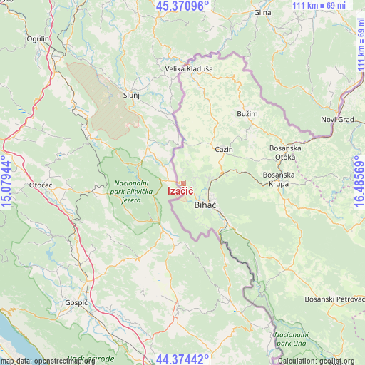
Izačić GPS coordinates[2]
44° 52' 29.46" North, 15° 46' 57.216" East
| Map corner | latitude | longitude |
|---|---|---|
| Upper-left | 45.37096°, | 15.07944° |
| Center: | 44.87485°, | 15.78256° |
| Lower-right: | 44.37442°, | 16.48569° |
| Map W x H: | 110.8×110.8 km | = 68.8×68.8mi |
| max Lat: | 45.21956° ⇑18.9% North |
| Izačić: | 44.87485° |
| min Lat: | ⇓81.1% South 42.71197° |
| min Long | Izačić | max Long |
| 15.77806° | 15.78256° | 19.36719° |
| W 0.4%⇐ | ⇒99.6% E |
Elevation
Elevation of Izačić is 329 m = 1079 ft, and this is 30.5 m = 100 ft below average elevation for this country.
| Max E: |
1175 m = 3855 ft | 41.9% |
| Avg. | 359.5 m = 1179 ft | |
| Izačić | 329 m = 1079 ft | |
Min E: |
17 m = 56 ft | 58.1% |
See also: Bosnia and Herzegovina elevation on elevation.city.
Geographical zone
Izačić is located in North temperate zone (between Tropic of Cancer and the Arctic Circle). Distance of this Northern Tropic circle is 2383.7 km =1481.2 mi to South.| Distance of | km | miles | from Izačić |
|---|---|---|---|
| North Pole | 5017.4 | 3117.7 | to North |
| Arctic Circle | 2411.6 | 1498.5 | to North |
| Tropic Cancer | 2383.7 | 1481.2 | to South |
| Equator | 4989.6 | 3100.4 | to South |


Nearby cities:
15 places around Izačić: (largest is in red/bold)
• Bihać
9.5 km =5.9 mi,  132°
132°
• Bužim
28 km =17.4 mi,  44°
44°
• Cazin
16.3 km =10.1 mi,  50°
50°
• Gornja Koprivna
20.3 km =12.6 mi, 41°
• Jezerski
27.3 km =17 mi,  64°
64°
• Ostrožac
13 km =8.1 mi,  73°
73°
• Pećigrad
21.9 km =13.6 mi,  24°
24°
• Pjanići
12.7 km =7.9 mi,  14°
14°
• Skokovi
20.3 km =12.6 mi,  30°
30°
• Stijena
20.1 km =12.5 mi, 70°
• Todorovo
26.4 km =16.4 mi, 26°
• Tržačka Raštela
11.2 km =7 mi,  0°
0°
• Ćoralići
16.3 km =10.1 mi, 25°
• Šturlić
21 km =13 mi,  359°
359°
• Šumatac
25.5 km =15.8 mi, 13°
Sources, notices
• [Note1] Compared only with cities in Bosnia and Herzegovina existing in our database
• [Src1] Map data: © OpenStreetMap contributors (CC-BY-SA)
• [Src2] Other city data from geonames.org with taken over terms of usage.
• [Src3] Geographical zone / Annual Mean Temperature by Robert A. Rohde @ Wikipedia
