Bihać geodata
Bihać (Federation of B&H) is a seat of a second-order administrative division; located in Bosnia and Herzegovina in Europe/Sarajevo (GMT+2) time zone. With population of 75,641 people, there are 5 cities with bigger population in this country. Compared to other cities in Bosnia and Herzegovina, 76.6% of cities are located further ↓South; 97.4% of cities are located further →East and 63.8% of cities have higher elevation than Bihać. Note1


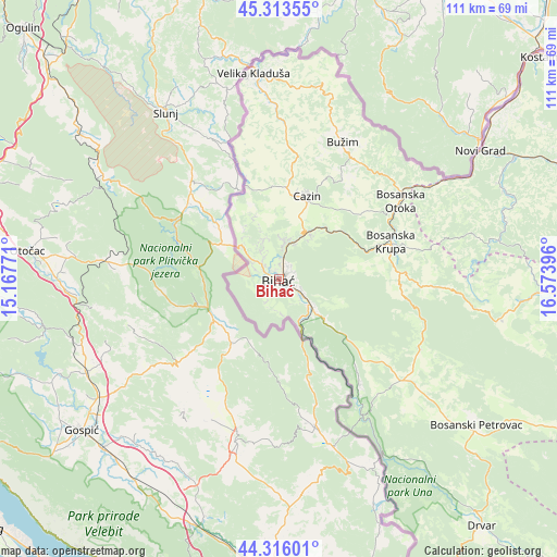
Bihać GPS coordinates[2]
44° 49' 0.984" North, 15° 52' 14.988" East
| Map corner | latitude | longitude |
|---|---|---|
| Upper-left | 45.31355°, | 15.16771° |
| Center: | 44.81694°, | 15.87083° |
| Lower-right: | 44.31601°, | 16.57396° |
| Map W x H: | 110.9×110.9 km | = 68.9×68.9mi |
| max Lat: | 45.21956° ⇑23.4% North |
| Bihać: | 44.81694° |
| min Lat: | ⇓76.6% South 42.71197° |
| min Long | Bihać | max Long |
| 15.77806° | 15.87083° | 19.36719° |
| W 2.6%⇐ | ⇒97.4% E |
Elevation
Elevation of Bihać is 223 m = 732 ft, and this is 136.5 m = 448 ft below average elevation for this country.
| Max E: |
1175 m = 3855 ft | 63.8% |
| Avg. | 359.5 m = 1179 ft | |
| Bihać | 223 m = 732 ft | |
Min E: |
17 m = 56 ft | 36.2% |
See also: Bihać elevation on elevation.city.
Geographical zone
Bihać is located in North temperate zone (between Tropic of Cancer and the Arctic Circle). Distance of this Northern Tropic circle is 2377.3 km =1477.2 mi to South.| Distance of | km | miles | from Bihać |
|---|---|---|---|
| North Pole | 5023.9 | 3121.7 | to North |
| Arctic Circle | 2418 | 1502.5 | to North |
| Tropic Cancer | 2377.3 | 1477.2 | to South |
| Equator | 4983.2 | 3096.4 | to South |


Nearby cities:
15 places around Bihać: (largest is in red/bold)
• Bosanska Krupa
23.3 km =14.5 mi,  71°
71°
• Cazin
17.6 km =10.9 mi,  18°
18°
• Gornja Koprivna
22.6 km =14 mi, 17°
• Izačić
9.5 km =5.9 mi,  312°
312°
• Jezerski
25.4 km =15.8 mi,  43°
43°
• Orašac
26.2 km =16.3 mi,  142°
142°
• Ostrožac
11.6 km =7.2 mi,  28°
28°
• Otoka
29 km =18 mi,  56°
56°
• Pećigrad
26.5 km =16.5 mi,  4°
4°
• Pjanići
19.1 km =11.9 mi,  348°
348°
• Skokovi
24.1 km =15 mi,  8°
8°
• Stijena
17.8 km =11.1 mi, 41°
• Tržačka Raštela
18.9 km =11.7 mi,  339°
339°
• Ćoralići
21.1 km =13.1 mi, 0°
• Šturlić
28.4 km =17.6 mi, 345°
Sources, notices
• [Note1] Compared only with cities in Bosnia and Herzegovina existing in our database
• [Src1] Map data: © OpenStreetMap contributors (CC-BY-SA)
• [Src2] Other city data from geonames.org with taken over terms of usage.
• [Src3] Geographical zone / Annual Mean Temperature by Robert A. Rohde @ Wikipedia
