Gacko geodata
Gacko (Srpska) is a seat of a second-order administrative division; located in Bosnia and Herzegovina in Europe/Sarajevo (GMT+2) time zone. With population of 3,417 people, there are 209 cities with bigger population in this country. Compared to other cities in Bosnia and Herzegovina, 96.2% of cities are located further ↑North; 76.6% of cities are located further ←West and 97% of cities have lower elevation than Gacko. Note1


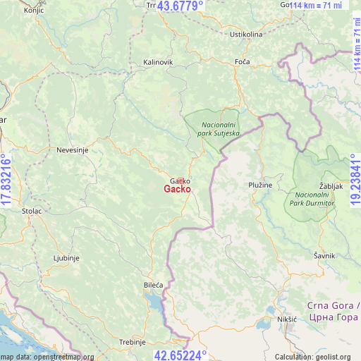
Gacko GPS coordinates[2]
43° 10' 1.992" North, 18° 32' 7.008" East
| Map corner | latitude | longitude |
|---|---|---|
| Upper-left | 43.6779°, | 17.83216° |
| Center: | 43.16722°, | 18.53528° |
| Lower-right: | 42.65224°, | 19.23841° |
| Map W x H: | 114×114 km | = 70.8×70.8mi |
| max Lat: | 45.21956° ⇑96.2% North |
| Gacko: | 43.16722° |
| min Lat: | ⇓3.8% South 42.71197° |
| min Long | Gacko | max Long |
| 15.77806° | 18.53528° | 19.36719° |
| W 76.6%⇐ | ⇒23.4% E |
Elevation
Elevation of Gacko is 970 m = 3182 ft, and this is 610.5 m = 2003 ft above average elevation for this country.
| Max E: |
1175 m = 3855 ft | 3% |
| Gacko | 970 m 3182 ft | |
| Avg. | 359.5 m = 1179 ft | |
Min E: |
17 m = 56 ft | 97% |
See also: Bosnia and Herzegovina elevation on elevation.city.
Geographical zone
Gacko is located in North temperate zone (between Tropic of Cancer and the Arctic Circle). Distance of this Northern Tropic circle is 2193.8 km =1363.2 mi to South.| Distance of | km | miles | from Gacko |
|---|---|---|---|
| North Pole | 5207.3 | 3235.7 | to North |
| Arctic Circle | 2601.4 | 1616.4 | to North |
| Tropic Cancer | 2193.8 | 1363.2 | to South |
| Equator | 4799.7 | 2982.4 | to South |


Nearby cities:
15 places around Gacko: (largest is in red/bold)
• Berkovići
30.7 km =19.1 mi,  254°
254°
• Bileća
33.5 km =20.8 mi,  194°
194°
• Blagaj
53.4 km =33.2 mi,  281°
281°
• Crnići
54.6 km =33.9 mi,  265°
265°
• Foča
42.5 km =26.4 mi,  27°
27°
• Kalinovik
38.2 km =23.7 mi,  349°
349°
• Ljubinje
43.6 km =27.1 mi,  236°
236°
• Nevesinje
35.7 km =22.2 mi,  286°
286°
• Potoci
59.6 km =37 mi,  296°
296°
• Ravno
55.8 km =34.7 mi, 236°
• Stolac
47.6 km =29.6 mi,  258°
258°
• Trebinje
53 km =32.9 mi,  197°
197°
• Trnovo
55.9 km =34.7 mi, 352°
• Ustikolina
50.7 km =31.5 mi,  24°
24°
• Čajniče
61.3 km =38.1 mi,  45°
45°
Sources, notices
• [Note1] Compared only with cities in Bosnia and Herzegovina existing in our database
• [Src1] Map data: © OpenStreetMap contributors (CC-BY-SA)
• [Src2] Other city data from geonames.org with taken over terms of usage.
• [Src3] Geographical zone / Annual Mean Temperature by Robert A. Rohde @ Wikipedia
