Trebinje geodata
Trebinje (Srpska) is a seat of a second-order administrative division; located in Bosnia and Herzegovina in Europe/Sarajevo (GMT+2) time zone. With population of 33,178 people, there are 10 cities with bigger population in this country. Compared to other cities in Bosnia and Herzegovina, 100% of cities are located further ↑North; 66.8% of cities are located further ←West and 53.2% of cities have higher elevation than Trebinje. Note1


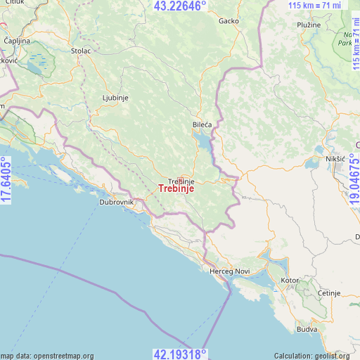
Trebinje GPS coordinates[2]
42° 42' 43.092" North, 18° 20' 37.032" East
| Map corner | latitude | longitude |
|---|---|---|
| Upper-left | 43.22646°, | 17.6405° |
| Center: | 42.71197°, | 18.34362° |
| Lower-right: | 42.19318°, | 19.04675° |
| Map W x H: | 114.9×114.9 km | = 71.4×71.4mi |
| max Lat: | 45.21956° ⇑100% North |
| Trebinje: | 42.71197° |
| min Lat: | ⇓0% South 42.71197° |
| min Long | Trebinje | max Long |
| 15.77806° | 18.34362° | 19.36719° |
| W 66.8%⇐ | ⇒33.2% E |
Elevation
Elevation of Trebinje is 278 m = 912 ft, and this is 81.5 m = 267 ft below average elevation for this country.
| Max E: |
1175 m = 3855 ft | 53.2% |
| Avg. | 359.5 m = 1179 ft | |
| Trebinje | 278 m = 912 ft | |
Min E: |
17 m = 56 ft | 46.8% |
See also: Bosnia and Herzegovina elevation on elevation.city.
Geographical zone
Trebinje is located in North temperate zone (between Tropic of Cancer and the Arctic Circle). Distance of this Northern Tropic circle is 2143.2 km =1331.7 mi to South.| Distance of | km | miles | from Trebinje |
|---|---|---|---|
| North Pole | 5257.9 | 3267.1 | to North |
| Arctic Circle | 2652 | 1647.9 | to North |
| Tropic Cancer | 2143.2 | 1331.7 | to South |
| Equator | 4749.1 | 2951 | to South |


Nearby cities:
15 places around Trebinje: (largest is in red/bold)
• Berkovići
44.8 km =27.8 mi,  341°
341°
• Bileća
19.6 km =12.2 mi,  21°
21°
• Blagaj
71.2 km =44.2 mi,  328°
328°
• Crnići
60.8 km =37.8 mi,  320°
320°
• Gacko
53 km =32.9 mi, 17°
• Ljubinje
33.8 km =21 mi, 321°
• Mostar
82.6 km =51.3 mi, 328°
• Neum
63.9 km =39.7 mi,  291°
291°
• Nevesinje
63.6 km =39.5 mi, 342°
• Ravno
36.5 km =22.7 mi,  302°
302°
• Rodoč
80.1 km =49.8 mi, 326°
• Stolac
51.8 km =32.2 mi, 322°
• Tasovčići
67.6 km =42 mi,  311°
311°
• Čapljina
70.4 km =43.7 mi, 310°
• Čitluk
77.7 km =48.3 mi, 317°
Sources, notices
• [Note1] Compared only with cities in Bosnia and Herzegovina existing in our database
• [Src1] Map data: © OpenStreetMap contributors (CC-BY-SA)
• [Src2] Other city data from geonames.org with taken over terms of usage.
• [Src3] Geographical zone / Annual Mean Temperature by Robert A. Rohde @ Wikipedia
