Jablanica geodata
Jablanica (Federation of B&H) is a seat of a third-order administrative division; located in Bosnia and Herzegovina in Europe/Sarajevo (GMT+2) time zone. With population of 6,209 people, there are 88 cities with bigger population in this country. Compared to other cities in Bosnia and Herzegovina, 86% of cities are located further ↑North; 58.5% of cities are located further →East and 69.4% of cities have higher elevation than Jablanica. Note1


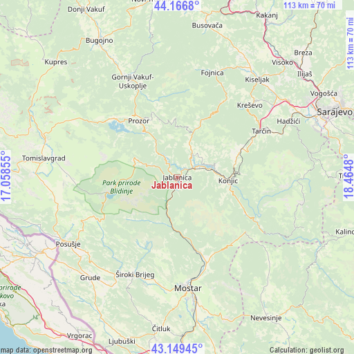
Jablanica GPS coordinates[2]
43° 39' 37.008" North, 17° 45' 42.012" East
| Map corner | latitude | longitude |
|---|---|---|
| Upper-left | 44.1668°, | 17.05855° |
| Center: | 43.66028°, | 17.76167° |
| Lower-right: | 43.14945°, | 18.4648° |
| Map W x H: | 113.1×113.1 km | = 70.3×70.3mi |
| max Lat: | 45.21956° ⇑86% North |
| Jablanica: | 43.66028° |
| min Lat: | ⇓14% South 42.71197° |
| min Long | Jablanica | max Long |
| 15.77806° | 17.76167° | 19.36719° |
| W 41.5%⇐ | ⇒58.5% E |
Elevation
Elevation of Jablanica is 199 m = 653 ft, and this is 160.5 m = 527 ft below average elevation for this country.
| Max E: |
1175 m = 3855 ft | 69.4% |
| Avg. | 359.5 m = 1179 ft | |
| Jablanica | 199 m = 653 ft | |
Min E: |
17 m = 56 ft | 30.6% |
See also: Bosnia and Herzegovina elevation on elevation.city.
Geographical zone
Jablanica is located in North temperate zone (between Tropic of Cancer and the Arctic Circle). Distance of this Northern Tropic circle is 2248.6 km =1397.2 mi to South.| Distance of | km | miles | from Jablanica |
|---|---|---|---|
| North Pole | 5152.5 | 3201.6 | to North |
| Arctic Circle | 2546.6 | 1582.4 | to North |
| Tropic Cancer | 2248.6 | 1397.2 | to South |
| Equator | 4854.6 | 3016.5 | to South |


Nearby cities:
15 places around Jablanica: (largest is in red/bold)
• Bijela
16.3 km =10.1 mi,  110°
110°
• Cim
34.1 km =21.2 mi,  177°
177°
• Fojnica
35.1 km =21.8 mi,  18°
18°
• Gornji Vakuf
33.9 km =21.1 mi,  335°
335°
• Ilići
34.8 km =21.6 mi, 179°
• Konjic
16.1 km =10 mi,  93°
93°
• Kreševo
32.1 km =19.9 mi,  44°
44°
• Pazarić
35.1 km =21.8 mi,  65°
65°
• Polje
35.1 km =21.8 mi,  45°
45°
• Polje-Bijela
17.2 km =10.7 mi,  100°
100°
• Potoci
29.4 km =18.3 mi,  161°
161°
• Prozor
21.8 km =13.5 mi,  325°
325°
• Rumboci
28.2 km =17.5 mi,  312°
312°
• Voljevac
25.7 km =16 mi, 341°
• Široki Brijeg
33.7 km =20.9 mi,  203°
203°
Sources, notices
• [Note1] Compared only with cities in Bosnia and Herzegovina existing in our database
• [Src1] Map data: © OpenStreetMap contributors (CC-BY-SA)
• [Src2] Other city data from geonames.org with taken over terms of usage.
• [Src3] Geographical zone / Annual Mean Temperature by Robert A. Rohde @ Wikipedia
