Varshets geodata
Varshets (Montana) is a seat of a second-order administrative division; located in Bulgaria in Europe/Sofia (GMT+3) time zone. With population of 7,512 people, there are 101 cities with bigger population in this country. Compared to other cities in Bulgaria, 65% of cities are located further ↓South; 83.7% of cities are located further →East and 71.3% of cities have lower elevation than Varshets. Note1


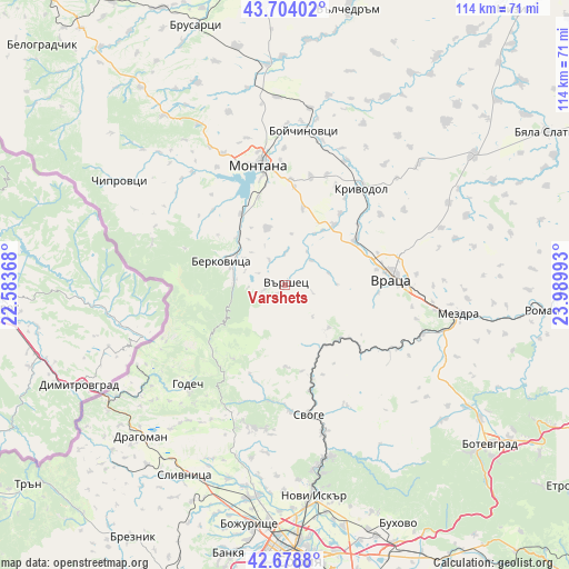
Varshets GPS coordinates[2]
43° 11' 36.816" North, 23° 17' 12.48" East
| Map corner | latitude | longitude |
|---|---|---|
| Upper-left | 43.70402°, | 22.58368° |
| Center: | 43.19356°, | 23.2868° |
| Lower-right: | 42.6788°, | 23.98993° |
| Map W x H: | 114×114 km | = 70.8×70.8mi |
| max Lat: | 44.16214° ⇑35% North |
| Varshets: | 43.19356° |
| min Lat: | ⇓65% South 41.32715° |
| min Long | Varshets | max Long |
| 22.52139° | 23.2868° | 28.53429° |
| W 16.3%⇐ | ⇒83.7% E |
Elevation
Elevation of Varshets is 408 m = 1339 ft, and this is 91.4 m = 300 ft above average elevation for this country.
| Max E: |
1221 m = 4006 ft | 28.7% |
| Varshets | 408 m 1339 ft | |
| Avg. | 316.6 m = 1039 ft | |
Min E: |
1 m = 3 ft | 71.3% |
See also: Bulgaria elevation on elevation.city.
Geographical zone
Varshets is located in North temperate zone (between Tropic of Cancer and the Arctic Circle). Distance of this Northern Tropic circle is 2196.8 km =1365 mi to South.| Distance of | km | miles | from Varshets |
|---|---|---|---|
| North Pole | 5204.4 | 3233.9 | to North |
| Arctic Circle | 2598.5 | 1614.6 | to North |
| Tropic Cancer | 2196.8 | 1365 | to South |
| Equator | 4802.7 | 2984.3 | to South |


Nearby cities:
15 places around Varshets: (largest is in red/bold)
• Berkovitsa
13.7 km =8.5 mi,  289°
289°
• Bov
19.4 km =12.1 mi,  157°
157°
• Boychinovtsi
31.2 km =19.4 mi,  7°
7°
• Chiprovtsi
39.1 km =24.3 mi,  302°
302°
• Dragoman
41.8 km =26 mi,  223°
223°
• Georgi Damyanovo
29.8 km =18.5 mi,  315°
315°
• Godech
27.6 km =17.1 mi, 224°
• Kostinbrod
42.3 km =26.3 mi,  187°
187°
• Krivodol
25.7 km =16 mi,  38°
38°
• Lakatnik
18.4 km =11.4 mi,  150°
150°
• Mezdra
33.9 km =21.1 mi,  98°
98°
• Montana
24.9 km =15.5 mi,  348°
348°
• Slivnitsa
43 km =26.7 mi,  208°
208°
• Svoge
25.7 km =16 mi,  168°
168°
• Vratsa
22.4 km =13.9 mi,  85°
85°
Sources, notices
• [Note1] Compared only with cities in Bulgaria existing in our database
• [Src1] Map data: © OpenStreetMap contributors (CC-BY-SA)
• [Src2] Other city data from geonames.org with taken over terms of usage.
• [Src3] Geographical zone / Annual Mean Temperature by Robert A. Rohde @ Wikipedia
