Slivnitsa geodata
Slivnitsa (Sofia) is a seat of a second-order administrative division; located in Bulgaria in Europe/Sofia (GMT+3) time zone. With population of 7,545 people, there are 100 cities with bigger population in this country. Compared to other cities in Bulgaria, 50.7% of cities are located further ↓South; 91% of cities are located further →East and 83.7% of cities have lower elevation than Slivnitsa. Note1


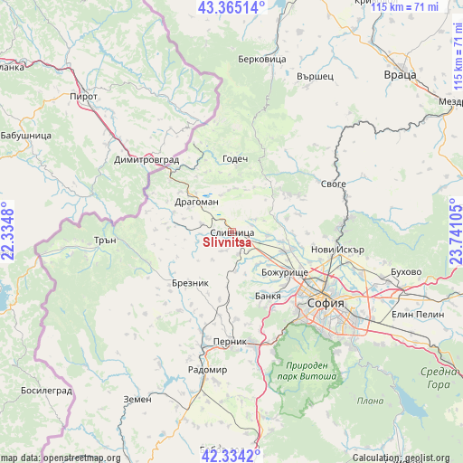
Slivnitsa GPS coordinates[2]
42° 51' 6.552" North, 23° 2' 16.512" East
| Map corner | latitude | longitude |
|---|---|---|
| Upper-left | 43.36514°, | 22.3348° |
| Center: | 42.85182°, | 23.03792° |
| Lower-right: | 42.3342°, | 23.74105° |
| Map W x H: | 114.6×114.6 km | = 71.2×71.2mi |
| max Lat: | 44.16214° ⇑49.3% North |
| Slivnitsa: | 42.85182° |
| min Lat: | ⇓50.7% South 41.32715° |
| min Long | Slivnitsa | max Long |
| 22.52139° | 23.03792° | 28.53429° |
| W 9%⇐ | ⇒91% E |
Elevation
Elevation of Slivnitsa is 591 m = 1939 ft, and this is 274.4 m = 900 ft above average elevation for this country.
| Max E: |
1221 m = 4006 ft | 16.3% |
| Slivnitsa | 591 m 1939 ft | |
| Avg. | 316.6 m = 1039 ft | |
Min E: |
1 m = 3 ft | 83.7% |
See also: Bulgaria elevation on elevation.city.
Geographical zone
Slivnitsa is located in North temperate zone (between Tropic of Cancer and the Arctic Circle). Distance of this Northern Tropic circle is 2158.8 km =1341.4 mi to South.| Distance of | km | miles | from Slivnitsa |
|---|---|---|---|
| North Pole | 5242.4 | 3257.5 | to North |
| Arctic Circle | 2636.5 | 1638.2 | to North |
| Tropic Cancer | 2158.8 | 1341.4 | to South |
| Equator | 4764.7 | 2960.6 | to South |


Nearby cities:
15 places around Slivnitsa: (largest is in red/bold)
• Batanovtsi
29.1 km =18.1 mi,  193°
193°
• Berkovitsa
43.3 km =26.9 mi,  9°
9°
• Bov
34.2 km =21.3 mi,  54°
54°
• Bozhurishte
17.4 km =10.8 mi,  130°
130°
• Breznik
16.3 km =10.1 mi,  220°
220°
• Dragoman
11.7 km =7.3 mi,  311°
311°
• Godech
18.4 km =11.4 mi,  2°
2°
• Kostinbrod
15.1 km =9.4 mi,  105°
105°
• Lakatnik
36.8 km =22.9 mi, 53°
• Pernik
28 km =17.4 mi,  180°
180°
• Radomir
34.6 km =21.5 mi, 189°
• Sofia
29 km =18 mi, 126°
• Svoge
28.4 km =17.6 mi,  63°
63°
• Tran
31.5 km =19.6 mi,  266°
266°
• Varshets
43 km =26.7 mi,  28°
28°
Sources, notices
• [Note1] Compared only with cities in Bulgaria existing in our database
• [Src1] Map data: © OpenStreetMap contributors (CC-BY-SA)
• [Src2] Other city data from geonames.org with taken over terms of usage.
• [Src3] Geographical zone / Annual Mean Temperature by Robert A. Rohde @ Wikipedia
