Lukovit geodata
Lukovit (Lovech) is a populated place; located in Bulgaria in Europe/Sofia (GMT+3) time zone. With population of 9,792 people, there are 78 cities with bigger population in this country. Compared to other cities in Bulgaria, 65.3% of cities are located further ↓South; 67% of cities are located further →East and 70.3% of cities have higher elevation than Lukovit. Note1


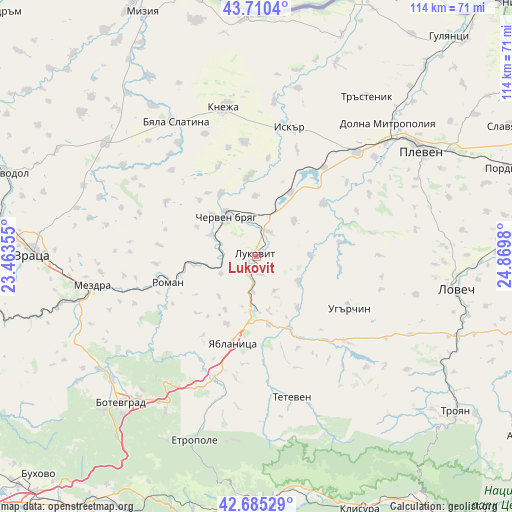
Lukovit GPS coordinates[2]
43° 12' 0" North, 24° 10' 0.012" East
| Map corner | latitude | longitude |
|---|---|---|
| Upper-left | 43.7104°, | 23.46355° |
| Center: | 43.2°, | 24.16667° |
| Lower-right: | 42.68529°, | 24.8698° |
| Map W x H: | 114×114 km | = 70.8×70.8mi |
| max Lat: | 44.16214° ⇑34.7% North |
| Lukovit: | 43.2° |
| min Lat: | ⇓65.3% South 41.32715° |
| min Long | Lukovit | max Long |
| 22.52139° | 24.16667° | 28.53429° |
| W 33%⇐ | ⇒67% E |
Elevation
Elevation of Lukovit is 136 m = 446 ft, and this is 180.6 m = 593 ft below average elevation for this country.
| Max E: |
1221 m = 4006 ft | 70.3% |
| Avg. | 316.6 m = 1039 ft | |
| Lukovit | 136 m = 446 ft | |
Min E: |
1 m = 3 ft | 29.7% |
See also: Bulgaria elevation on elevation.city.
Geographical zone
Lukovit is located in North temperate zone (between Tropic of Cancer and the Arctic Circle). Distance of this Northern Tropic circle is 2197.5 km =1365.5 mi to South.| Distance of | km | miles | from Lukovit |
|---|---|---|---|
| North Pole | 5203.7 | 3233.4 | to North |
| Arctic Circle | 2597.8 | 1614.2 | to North |
| Tropic Cancer | 2197.5 | 1365.5 | to South |
| Equator | 4803.4 | 2984.7 | to South |


Nearby cities:
15 places around Lukovit: (largest is in red/bold)
• Borovan
42.5 km =26.4 mi,  307°
307°
• Byala Slatina
35.1 km =21.8 mi,  327°
327°
• Cherven Bryag
11.1 km =6.9 mi,  322°
322°
• Dolna Mitropolia
41.9 km =26 mi,  45°
45°
• Dolni Dabnik
31 km =19.3 mi,  44°
44°
• Etropole
43 km =26.7 mi,  198°
198°
• Iskar
29 km =18 mi,  16°
16°
• Knezha
34 km =21.1 mi,  348°
348°
• Koynare
16.9 km =10.5 mi, 350°
• Mezdra
38.2 km =23.7 mi,  261°
261°
• Pravets
40.7 km =25.3 mi,  209°
209°
• Roman
21 km =13 mi,  254°
254°
• Teteven
32.5 km =20.2 mi,  165°
165°
• Ugarchin
23.1 km =14.4 mi,  118°
118°
• Yablanitsa
19.3 km =12 mi,  193°
193°
Sources, notices
• [Note1] Compared only with cities in Bulgaria existing in our database
• [Src1] Map data: © OpenStreetMap contributors (CC-BY-SA)
• [Src2] Other city data from geonames.org with taken over terms of usage.
• [Src3] Geographical zone / Annual Mean Temperature by Robert A. Rohde @ Wikipedia
