Teteven geodata
Teteven (Lovech) is a populated place; located in Bulgaria in Europe/Sofia (GMT+3) time zone. With population of 10,790 people, there are 76 cities with bigger population in this country. Compared to other cities in Bulgaria, 53.3% of cities are located further ↓South; 65.7% of cities are located further →East and 72.3% of cities have lower elevation than Teteven. Note1


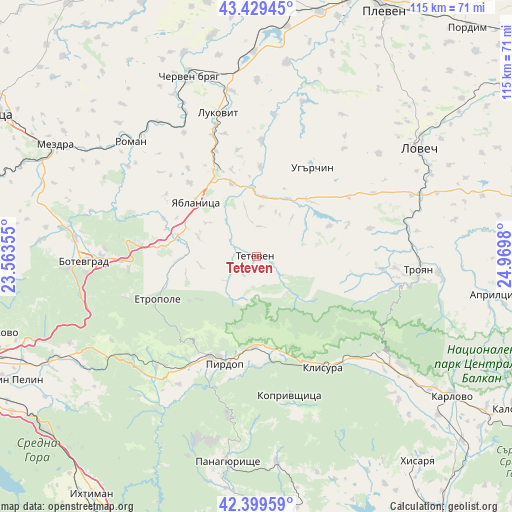
Teteven GPS coordinates[2]
42° 55' 0.012" North, 24° 16' 0.012" East
| Map corner | latitude | longitude |
|---|---|---|
| Upper-left | 43.42945°, | 23.56355° |
| Center: | 42.91667°, | 24.26667° |
| Lower-right: | 42.39959°, | 24.9698° |
| Map W x H: | 114.5×114.5 km | = 71.1×71.1mi |
| max Lat: | 44.16214° ⇑46.7% North |
| Teteven: | 42.91667° |
| min Lat: | ⇓53.3% South 41.32715° |
| min Long | Teteven | max Long |
| 22.52139° | 24.26667° | 28.53429° |
| W 34.3%⇐ | ⇒65.7% E |
Elevation
Elevation of Teteven is 419 m = 1375 ft, and this is 102.4 m = 336 ft above average elevation for this country.
| Max E: |
1221 m = 4006 ft | 27.7% |
| Teteven | 419 m 1375 ft | |
| Avg. | 316.6 m = 1039 ft | |
Min E: |
1 m = 3 ft | 72.3% |
See also: Bulgaria elevation on elevation.city.
Geographical zone
Teteven is located in North temperate zone (between Tropic of Cancer and the Arctic Circle). Distance of this Northern Tropic circle is 2166 km =1345.9 mi to South.| Distance of | km | miles | from Teteven |
|---|---|---|---|
| North Pole | 5235.2 | 3253 | to North |
| Arctic Circle | 2629.3 | 1633.8 | to North |
| Tropic Cancer | 2166 | 1345.9 | to South |
| Equator | 4771.9 | 2965.1 | to South |


Nearby cities:
15 places around Teteven: (largest is in red/bold)
• Anton
18.6 km =11.6 mi,  175°
175°
• Chavdar
34.5 km =21.4 mi,  210°
210°
• Chelopech
28.4 km =17.6 mi, 211°
• Etropole
23.6 km =14.7 mi,  246°
246°
• Klisura
28.4 km =17.6 mi,  148°
148°
• Koprivshtitsa
32.2 km =20 mi,  167°
167°
• Lukovit
32.5 km =20.2 mi,  345°
345°
• Mirkovo
33.4 km =20.8 mi,  223°
223°
• Pirdop
25 km =15.5 mi,  195°
195°
• Pravets
28.7 km =17.8 mi,  262°
262°
• Roman
38.5 km =23.9 mi,  312°
312°
• Troyan
36.7 km =22.8 mi,  93°
93°
• Ugarchin
23.8 km =14.8 mi,  30°
30°
• Yablanitsa
17.9 km =11.1 mi,  315°
315°
• Zlatitsa
24.8 km =15.4 mi, 206°
Sources, notices
• [Note1] Compared only with cities in Bulgaria existing in our database
• [Src1] Map data: © OpenStreetMap contributors (CC-BY-SA)
• [Src2] Other city data from geonames.org with taken over terms of usage.
• [Src3] Geographical zone / Annual Mean Temperature by Robert A. Rohde @ Wikipedia
