Ivanovo geodata
Ivanovo (Ruse) is a seat of a second-order administrative division; located in Bulgaria in Europe/Sofia (GMT+3) time zone. With population of 1,031 people, there are 272 cities with bigger population in this country. Compared to other cities in Bulgaria, 88% of cities are located further ↓South; 67.7% of cities are located further ←West and 62% of cities have higher elevation than Ivanovo. Note1


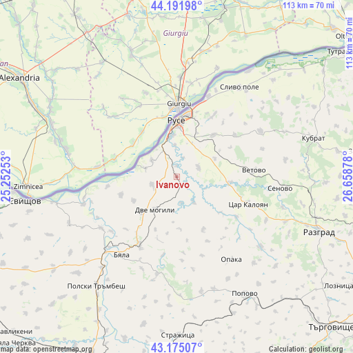
Ivanovo GPS coordinates[2]
43° 41' 8.448" North, 25° 57' 20.34" East
| Map corner | latitude | longitude |
|---|---|---|
| Upper-left | 44.19198°, | 25.25253° |
| Center: | 43.68568°, | 25.95565° |
| Lower-right: | 43.17507°, | 26.65878° |
| Map W x H: | 113.1×113.1 km | = 70.3×70.3mi |
| max Lat: | 44.16214° ⇑12% North |
| Ivanovo: | 43.68568° |
| min Lat: | ⇓88% South 41.32715° |
| min Long | Ivanovo | max Long |
| 22.52139° | 25.95565° | 28.53429° |
| W 67.7%⇐ | ⇒32.3% E |
Elevation
Elevation of Ivanovo is 180 m = 591 ft, and this is 136.6 m = 448 ft below average elevation for this country.
| Max E: |
1221 m = 4006 ft | 62% |
| Avg. | 316.6 m = 1039 ft | |
| Ivanovo | 180 m = 591 ft | |
Min E: |
1 m = 3 ft | 38% |
See also: Bulgaria elevation on elevation.city.
Geographical zone
Ivanovo is located in North temperate zone (between Tropic of Cancer and the Arctic Circle). Distance of this Northern Tropic circle is 2251.5 km =1399 mi to South.| Distance of | km | miles | from Ivanovo |
|---|---|---|---|
| North Pole | 5149.7 | 3199.9 | to North |
| Arctic Circle | 2543.8 | 1580.6 | to North |
| Tropic Cancer | 2251.5 | 1399 | to South |
| Equator | 4857.4 | 3018.2 | to South |


Nearby cities:
15 places around Ivanovo: (largest is in red/bold)
• Borovo
23.7 km =14.7 mi,  209°
209°
• Dve Mogili
12.2 km =7.6 mi, 212°
• Gorichevo
43.7 km =27.2 mi,  65°
65°
• Kubrat
45.5 km =28.3 mi, 74°
• Medovene
46 km =28.6 mi,  78°
78°
• Opaka
31.2 km =19.4 mi,  147°
147°
• Polski Trambesh
43.4 km =27 mi,  216°
216°
• Popovo
43.5 km =27 mi, 149°
• Ruse
18.1 km =11.2 mi,  359°
359°
• Senovo
33.3 km =20.7 mi,  96°
96°
• Slivo Pole
34.8 km =21.6 mi,  34°
34°
• Tochilari
44.9 km =27.9 mi, 65°
• Tsar Kaloyan
24.9 km =15.5 mi,  107°
107°
• Tsenovo
29.2 km =18.1 mi,  235°
235°
• Vetovo
25.1 km =15.6 mi,  86°
86°
Sources, notices
• [Note1] Compared only with cities in Bulgaria existing in our database
• [Src1] Map data: © OpenStreetMap contributors (CC-BY-SA)
• [Src2] Other city data from geonames.org with taken over terms of usage.
• [Src3] Geographical zone / Annual Mean Temperature by Robert A. Rohde @ Wikipedia
