Kubrat geodata
Kubrat (Razgrad) is a seat of a second-order administrative division; located in Bulgaria in Europe/Sofia (GMT+3) time zone. With population of 8,980 people, there are 86 cities with bigger population in this country. Compared to other cities in Bulgaria, 93.3% of cities are located further ↓South; 74.7% of cities are located further ←West and 55.7% of cities have higher elevation than Kubrat. Note1


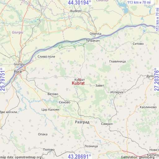
Kubrat GPS coordinates[2]
43° 47' 47.688" North, 26° 30' 2.268" East
| Map corner | latitude | longitude |
|---|---|---|
| Upper-left | 44.30194°, | 25.79751° |
| Center: | 43.79658°, | 26.50063° |
| Lower-right: | 43.28691°, | 27.20376° |
| Map W x H: | 112.9×112.9 km | = 70.2×70.2mi |
| max Lat: | 44.16214° ⇑6.7% North |
| Kubrat: | 43.79658° |
| min Lat: | ⇓93.3% South 41.32715° |
| min Long | Kubrat | max Long |
| 22.52139° | 26.50063° | 28.53429° |
| W 74.7%⇐ | ⇒25.3% E |
Elevation
Elevation of Kubrat is 202 m = 663 ft, and this is 114.6 m = 376 ft below average elevation for this country.
| Max E: |
1221 m = 4006 ft | 55.7% |
| Avg. | 316.6 m = 1039 ft | |
| Kubrat | 202 m = 663 ft | |
Min E: |
1 m = 3 ft | 44.3% |
See also: Bulgaria elevation on elevation.city.
Geographical zone
Kubrat is located in North temperate zone (between Tropic of Cancer and the Arctic Circle). Distance of this Northern Tropic circle is 2263.8 km =1406.7 mi to South.| Distance of | km | miles | from Kubrat |
|---|---|---|---|
| North Pole | 5137.3 | 3192.2 | to North |
| Arctic Circle | 2531.5 | 1573 | to North |
| Tropic Cancer | 2263.8 | 1406.7 | to South |
| Equator | 4869.7 | 3025.9 | to South |


Nearby cities:
15 places around Kubrat: (largest is in red/bold)
• Glavinitsa
29.8 km =18.5 mi,  63°
63°
• Gorichevo
7.2 km =4.5 mi,  325°
325°
• Isperih
28.2 km =17.5 mi,  108°
108°
• Medovene
3.6 km =2.2 mi,  158°
158°
• Razgrad
29.3 km =18.2 mi,  177°
177°
• Ruse
44.3 km =27.5 mi,  277°
277°
• Samuil
37 km =23 mi,  147°
147°
• Senovo
19.5 km =12.1 mi,  213°
213°
• Slivo Pole
28.7 km =17.8 mi,  304°
304°
• Tochilari
6.5 km =4 mi,  335°
335°
• Tsar Kaloyan
28.4 km =17.6 mi,  225°
225°
• Tutrakan
29.5 km =18.3 mi,  17°
17°
• Venets
44.3 km =27.5 mi,  128°
128°
• Vetovo
21.6 km =13.4 mi,  240°
240°
• Zavet
15 km =9.3 mi, 105°
Sources, notices
• [Note1] Compared only with cities in Bulgaria existing in our database
• [Src1] Map data: © OpenStreetMap contributors (CC-BY-SA)
• [Src2] Other city data from geonames.org with taken over terms of usage.
• [Src3] Geographical zone / Annual Mean Temperature by Robert A. Rohde @ Wikipedia
