Senhor do Bonfim geodata
Senhor do Bonfim (Bahia) is a populated place; located in Brazil in America/Bahia (GMT-3) time zone. With population of 48,471 people, there are 443 cities with bigger population in this country. Compared to other cities in Brazil, 66.7% of cities are located further ↓South; 74.5% of cities are located further ←West and 67% of cities have lower elevation than Senhor do Bonfim. Note1


Senhor do Bonfim GPS coordinates[2]
10° 27' 41.004" South, 40° 11' 21.984" West
| Map corner | latitude | longitude |
|---|---|---|
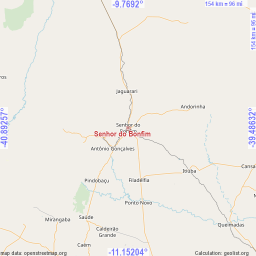
| Upper-left | -9.7692°, | -40.89257° |
| Center: | -10.46139°, | -40.18944° |
| Lower-right: | -11.15204°, | -39.48632° |
| Map W x H: | 153.8×153.8 km | = 95.6×95.6mi |
| max Lat: | 2.81972° ⇑33.3% North |
| Senhor do Bonfim: | -10.46139° |
| min Lat: | ⇓66.7% South -33.69111° |
| min Long | Senhor do Bonfi | max Long |
| -72.89583° | -40.18944° | -32.41083° |
| W 74.5%⇐ | ⇒25.5% E |
Elevation
Elevation of Senhor do Bonfim is 544 m = 1785 ft, and this is 163.1 m = 535 ft above average elevation for this country.
| Max E: |
1603 m = 5259 ft | 33% |
| Senhor do Bonfim | 544 m 1785 ft | |
| Avg. | 380.9 m = 1250 ft | |
Min E: |
0 m = 0 ft | 67% |
See also: Senhor do Bonfim elevation on elevation.city.
Geographical zone
Senhor do Bonfim is located in South Torrid zone (between Equator and Tropic of Capricorn). Distance of Equator is 1163.2 km =722.8 mi to North.| Distance of | km | miles | from Senhor do Bonfim |
|---|---|---|---|
| Equator | 1163.2 | 722.8 | to North |
| Tropic Capricorn | 1442.7 | 896.5 | to South |
| Antarctic Circle | 6238 | 3876.1 | to South |
| South Pole | 8843.9 | 5495.3 | to South |


Nearby cities:
15 places around Senhor do Bonfim: (largest is in red/bold)
• Campo Formoso
15.3 km =9.5 mi,  250°
250°
• Capim Grosso
104.1 km =64.7 mi,  169°
169°
• Euclides da Cunha
128.4 km =79.8 mi,  92°
92°
• Jacobina
87.5 km =54.4 mi,  203°
203°
• Jaguarari
22 km =13.7 mi,  358°
358°
• Laje
90.7 km =56.4 mi,  289°
289°
• Miguel Calmon
116.3 km =72.3 mi, 202°
• Monte Santo
93.7 km =58.2 mi, 88°
• Petrolina
123 km =76.4 mi,  343°
343°
• Pindobaçu
36.4 km =22.6 mi,  211°
211°
• Ponto Novo
45 km =28 mi, 172°
• Queimadas
84.2 km =52.3 mi,  133°
133°
• Quijingue
111.9 km =69.5 mi,  106°
106°
• Santaluz
125.4 km =77.9 mi, 134°
• Uauá
103.7 km =64.4 mi,  48°
48°
Sources, notices
• [Note1] Compared only with cities in Brazil existing in our database
• [Src1] Map data: © OpenStreetMap contributors (CC-BY-SA)
• [Src2] Other city data from geonames.org with taken over terms of usage.
• [Src3] Geographical zone / Annual Mean Temperature by Robert A. Rohde @ Wikipedia
