Laje geodata
Laje (Bahia) is a populated place; located in Brazil in America/Bahia (GMT-3) time zone. With population of 4,708 people, there are 1933 cities with bigger population in this country. Compared to other cities in Brazil, 67.4% of cities are located further ↓South; 70.2% of cities are located further ←West and 70.4% of cities have lower elevation than Laje. Note1


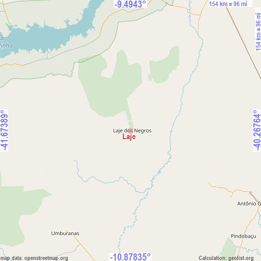
Laje GPS coordinates[2]
10° 11' 13.488" South, 40° 58' 14.736" West
| Map corner | latitude | longitude |
|---|---|---|
| Upper-left | -9.4943°, | -41.67389° |
| Center: | -10.18708°, | -40.97076° |
| Lower-right: | -10.87835°, | -40.26764° |
| Map W x H: | 153.9×153.9 km | = 95.6×95.6mi |
| max Lat: | 2.81972° ⇑32.6% North |
| Laje: | -10.18708° |
| min Lat: | ⇓67.4% South -33.69111° |
| min Long | Laje | max Long |
| -72.89583° | -40.97076° | -32.41083° |
| W 70.2%⇐ | ⇒29.8% E |
Elevation
Elevation of Laje is 576 m = 1890 ft, and this is 195.1 m = 640 ft above average elevation for this country.
| Max E: |
1603 m = 5259 ft | 29.6% |
| Laje | 576 m 1890 ft | |
| Avg. | 380.9 m = 1250 ft | |
Min E: |
0 m = 0 ft | 70.4% |
See also: Brazil elevation on elevation.city.
Geographical zone
Laje is located in South Torrid zone (between Equator and Tropic of Capricorn). Distance of Equator is 1132.7 km =703.8 mi to North.| Distance of | km | miles | from Laje |
|---|---|---|---|
| Equator | 1132.7 | 703.8 | to North |
| Tropic Capricorn | 1473.2 | 915.4 | to South |
| Antarctic Circle | 6268.5 | 3895.1 | to South |
| South Pole | 8874.4 | 5514.3 | to South |


Nearby cities:
15 places around Laje: (largest is in red/bold)
• América Dourada
149.9 km =93.1 mi,  199°
199°
• Campo Formoso
79.5 km =49.4 mi,  116°
116°
• Capim Grosso
169 km =105 mi,  141°
141°
• Irecê
157.4 km =97.8 mi,  217°
217°
• Jacobina
121.3 km =75.4 mi,  155°
155°
• Jaguarari
85.2 km =52.9 mi,  95°
95°
• Lapão
162.9 km =101.2 mi, 215°
• Miguel Calmon
144 km =89.5 mi, 163°
• Morro do Chapéu
152.8 km =94.9 mi,  187°
187°
• Petrolina
101.7 km =63.2 mi,  30°
30°
• Pindobaçu
90.8 km =56.4 mi,  132°
132°
• Ponto Novo
118.4 km =73.6 mi, 129°
• Queimadas
171.3 km =106.4 mi, 120°
• Senhor do Bonfim
90.7 km =56.4 mi,  109°
109°
• Uauá
167.5 km =104.1 mi,  76°
76°
Sources, notices
• [Note1] Compared only with cities in Brazil existing in our database
• [Src1] Map data: © OpenStreetMap contributors (CC-BY-SA)
• [Src2] Other city data from geonames.org with taken over terms of usage.
• [Src3] Geographical zone / Annual Mean Temperature by Robert A. Rohde @ Wikipedia
