Santo Amaro da Imperatriz geodata
Santo Amaro da Imperatriz (Santa Catarina) is a populated place; located in Brazil in America/Sao_Paulo (GMT-3) time zone. With population of 18,418 people, there are 1016 cities with bigger population in this country. Compared to other cities in Brazil, 93.2% of cities are located further ↑North; 70% of cities are located further →East and 85.7% of cities have higher elevation than Santo Amaro da Imperatriz. Note1
Current local time in Santo Amaro da Imperatriz:
06:46 PM, TuesdayDifference from your time zone: hours


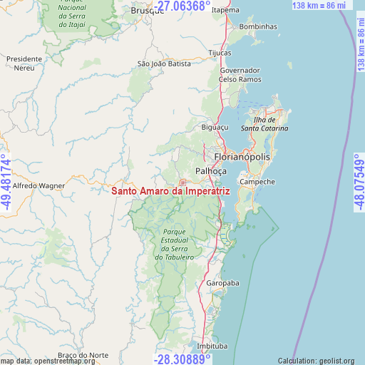
Santo Amaro da Imperatriz GPS coordinates[2]
27° 41' 17.016" South, 48° 46' 42.996" West
| Map corner | latitude | longitude |
|---|---|---|
| Upper-left | -27.06368°, | -49.48174° |
| Center: | -27.68806°, | -48.77861° |
| Lower-right: | -28.30889°, | -48.07549° |
| Map W x H: | 138.5×138.5 km | = 86.1×86.1mi |
| max Lat: | 2.81972° ⇑93.2% North |
| Santo Amaro da Imperatriz: | -27.68806° |
| min Lat: | ⇓6.8% South -33.69111° |
| min Long | Santo Amaro da | max Long |
| -72.89583° | -48.77861° | -32.41083° |
| W 30%⇐ | ⇒70% E |
Elevation
Elevation of Santo Amaro da Imperatriz is 29 m = 95 ft, and this is 351.9 m = 1155 ft below average elevation for this country.
| Max E: |
1603 m = 5259 ft | 85.7% |
| Avg. | 380.9 m = 1250 ft | |
| Santo Amaro da Imperatriz | 29 m = 95 ft | |
Min E: |
0 m = 0 ft | 14.3% |
See also: Brazil elevation on elevation.city.
Geographical zone
Santo Amaro da Imperatriz is located in South temperate zone (between Tropic of Capricorn and the Antarctic Circle). Distance of this Southern Tropic circle is 472.7 km =293.7 mi to North.| Distance of | km | miles | from Santo Amaro da Imperatriz |
|---|---|---|---|
| Equator | 3078.6 | 1913 | to North |
| Tropic Capricorn | 472.7 | 293.7 | to North |
| Antarctic Circle | 4322.6 | 2685.9 | to South |
| South Pole | 6928.4 | 4305.1 | to South |


Nearby cities:
15 places around Santo Amaro da Imperatriz: (largest is in red/bold)
• Acores
26.9 km =16.7 mi,  112°
112°
• Biguaçu
24.7 km =15.3 mi,  29°
29°
• Caiacanga da Barra do Sul
22 km =13.7 mi, 112°
• Campinas
19.9 km =12.4 mi,  58°
58°
• Carianos
23.4 km =14.5 mi,  82°
82°
• Carvoeira
26.8 km =16.7 mi,  68°
68°
• Costeira do Pirajubae
26 km =16.2 mi, 77°
• Florianópolis
24.8 km =15.4 mi, 65°
• Freguesia do Ribeirao da Ilha
21.5 km =13.4 mi,  98°
98°
• Morro da Cruz
26.5 km =16.5 mi, 64°
• Palhoça
11.9 km =7.4 mi, 66°
• Pantanal
27.2 km =16.9 mi, 71°
• Ribeirão da Ilha
24.3 km =15.1 mi,  92°
92°
• Saco dos Limoes
25.5 km =15.8 mi, 69°
• Tapera
22.4 km =13.9 mi, 89°
Sources, notices
• [Note1] Compared only with cities in Brazil existing in our database
• [Src1] Map data: © OpenStreetMap contributors (CC-BY-SA)
• [Src2] Other city data from geonames.org with taken over terms of usage.
• [Src3] Geographical zone / Annual Mean Temperature by Robert A. Rohde @ Wikipedia
