Lauro Muller geodata
Lauro Muller (Santa Catarina) is a populated place; located in Brazil in America/Sao_Paulo (GMT-3) time zone. With population of 10,035 people, there are 1649 cities with bigger population in this country. Compared to other cities in Brazil, 94.7% of cities are located further ↑North; 74.8% of cities are located further →East and 59.7% of cities have higher elevation than Lauro Muller. Note1


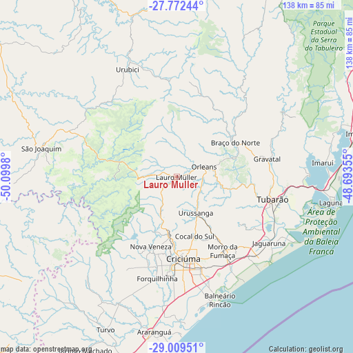
Lauro Muller GPS coordinates[2]
28° 23' 34.008" South, 49° 23' 48.012" West
| Map corner | latitude | longitude |
|---|---|---|
| Upper-left | -27.77244°, | -50.0998° |
| Center: | -28.39278°, | -49.39667° |
| Lower-right: | -29.00951°, | -48.69355° |
| Map W x H: | 137.5×137.6 km | = 85.4×85.5mi |
| max Lat: | 2.81972° ⇑94.7% North |
| Lauro Muller: | -28.39278° |
| min Lat: | ⇓5.3% South -33.69111° |
| min Long | Lauro Muller | max Long |
| -72.89583° | -49.39667° | -32.41083° |
| W 25.2%⇐ | ⇒74.8% E |
Elevation
Elevation of Lauro Muller is 218 m = 715 ft, and this is 162.9 m = 534 ft below average elevation for this country.
| Max E: |
1603 m = 5259 ft | 59.7% |
| Avg. | 380.9 m = 1250 ft | |
| Lauro Muller | 218 m = 715 ft | |
Min E: |
0 m = 0 ft | 40.3% |
See also: Brazil elevation on elevation.city.
Geographical zone
Lauro Muller is located in South temperate zone (between Tropic of Capricorn and the Antarctic Circle). Distance of this Southern Tropic circle is 551.1 km =342.4 mi to North.| Distance of | km | miles | from Lauro Muller |
|---|---|---|---|
| Equator | 3157 | 1961.7 | to North |
| Tropic Capricorn | 551.1 | 342.4 | to North |
| Antarctic Circle | 4244.2 | 2637.2 | to South |
| South Pole | 6850.1 | 4256.5 | to South |


Nearby cities:
15 places around Lauro Muller: (largest is in red/bold)
• Anitápolis
60.6 km =37.7 mi,  25°
25°
• Braço do Norte
26.1 km =16.2 mi,  59°
59°
• Cocal
24.3 km =15.1 mi,  163°
163°
• Criciúma
31.8 km =19.8 mi,  175°
175°
• Forquilhinha
40.1 km =24.9 mi,  190°
190°
• Içara
36.9 km =22.9 mi,  165°
165°
• Jaguaruna
44.3 km =27.5 mi,  125°
125°
• Laguna
61 km =37.9 mi,  99°
99°
• Morro da Fumaça
34 km =21.1 mi,  147°
147°
• Orleans
11 km =6.8 mi,  69°
69°
• Siderópolis
23 km =14.3 mi, 186°
• São Joaquim
53.5 km =33.2 mi,  281°
281°
• São José
30.5 km =19 mi,  48°
48°
• Tubarão
39 km =24.2 mi, 102°
• Urussanga
15.8 km =9.8 mi, 151°
Sources, notices
• [Note1] Compared only with cities in Brazil existing in our database
• [Src1] Map data: © OpenStreetMap contributors (CC-BY-SA)
• [Src2] Other city data from geonames.org with taken over terms of usage.
• [Src3] Geographical zone / Annual Mean Temperature by Robert A. Rohde @ Wikipedia
