Capela geodata
Capela (Sergipe) is a populated place; located in Brazil in America/Maceio (GMT-3) time zone. With population of 16,023 people, there are 1157 cities with bigger population in this country. Compared to other cities in Brazil, 66.5% of cities are located further ↓South; 88.8% of cities are located further ←West and 65.3% of cities have higher elevation than Capela. Note1


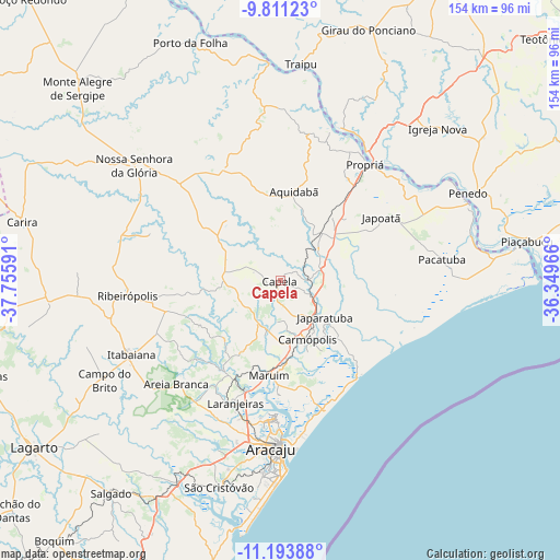
Capela GPS coordinates[2]
10° 30' 11.988" South, 37° 3' 10.008" West
| Map corner | latitude | longitude |
|---|---|---|
| Upper-left | -9.81123°, | -37.75591° |
| Center: | -10.50333°, | -37.05278° |
| Lower-right: | -11.19388°, | -36.34966° |
| Map W x H: | 153.7×153.7 km | = 95.5×95.5mi |
| max Lat: | 2.81972° ⇑33.5% North |
| Capela: | -10.50333° |
| min Lat: | ⇓66.5% South -33.69111° |
| min Long | Capela | max Long |
| -72.89583° | -37.05278° | -32.41083° |
| W 88.8%⇐ | ⇒11.2% E |
Elevation
Elevation of Capela is 165 m = 541 ft, and this is 215.9 m = 708 ft below average elevation for this country.
| Max E: |
1603 m = 5259 ft | 65.3% |
| Avg. | 380.9 m = 1250 ft | |
| Capela | 165 m = 541 ft | |
Min E: |
0 m = 0 ft | 34.7% |
See also: Brazil elevation on elevation.city.
Geographical zone
Capela is located in South Torrid zone (between Equator and Tropic of Capricorn). Distance of Equator is 1167.9 km =725.7 mi to North.| Distance of | km | miles | from Capela |
|---|---|---|---|
| Equator | 1167.9 | 725.7 | to North |
| Tropic Capricorn | 1438.1 | 893.6 | to South |
| Antarctic Circle | 6233.3 | 3873.2 | to South |
| South Pole | 8839.2 | 5492.4 | to South |


Nearby cities:
15 places around Capela: (largest is in red/bold)
• Aquidabã
25 km =15.5 mi,  8°
8°
• Areia Branca
40.3 km =25 mi,  225°
225°
• Japaratuba
15.9 km =9.9 mi,  129°
129°
• Japoatã
32.6 km =20.3 mi,  57°
57°
• Laranjeiras
36 km =22.4 mi,  200°
200°
• Malhador
32.5 km =20.2 mi,  238°
238°
• Maruim
26.2 km =16.3 mi,  186°
186°
• Moita Bonita
32.8 km =20.4 mi,  255°
255°
• Nossa Senhora das Dores
15.4 km =9.6 mi,  274°
274°
• Nossa Senhora do Socorro
39.9 km =24.8 mi, 191°
• Pacatuba
44.2 km =27.5 mi,  82°
82°
• Porto Real do Colégio
42.3 km =26.3 mi,  33°
33°
• Propriá
39.9 km =24.8 mi,  35°
35°
• Ribeirópolis
40 km =24.9 mi, 264°
• Santo Amaro das Brotas
31.8 km =19.8 mi,  180°
180°
Sources, notices
• [Note1] Compared only with cities in Brazil existing in our database
• [Src1] Map data: © OpenStreetMap contributors (CC-BY-SA)
• [Src2] Other city data from geonames.org with taken over terms of usage.
• [Src3] Geographical zone / Annual Mean Temperature by Robert A. Rohde @ Wikipedia
