Malhador geodata
Malhador (Sergipe) is a populated place; located in Brazil in America/Maceio (GMT-3) time zone. With population of 5,574 people, there are 1895 cities with bigger population in this country. Compared to other cities in Brazil, 66.1% of cities are located further ↓South; 87.5% of cities are located further ←West and 55.4% of cities have higher elevation than Malhador. Note1


Malhador GPS coordinates[2]
10° 39' 28.008" South, 37° 18' 16.992" West
| Map corner | latitude | longitude |
|---|---|---|
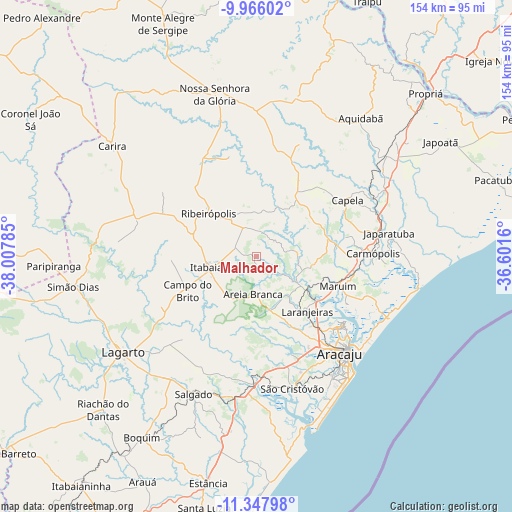
| Upper-left | -9.96602°, | -38.00785° |
| Center: | -10.65778°, | -37.30472° |
| Lower-right: | -11.34798°, | -36.6016° |
| Map W x H: | 153.7×153.7 km | = 95.5×95.5mi |
| max Lat: | 2.81972° ⇑33.9% North |
| Malhador: | -10.65778° |
| min Lat: | ⇓66.1% South -33.69111° |
| min Long | Malhador | max Long |
| -72.89583° | -37.30472° | -32.41083° |
| W 87.5%⇐ | ⇒12.5% E |
Elevation
Elevation of Malhador is 263 m = 863 ft, and this is 117.9 m = 387 ft below average elevation for this country.
| Max E: |
1603 m = 5259 ft | 55.4% |
| Avg. | 380.9 m = 1250 ft | |
| Malhador | 263 m = 863 ft | |
Min E: |
0 m = 0 ft | 44.6% |
See also: Brazil elevation on elevation.city.
Geographical zone
Malhador is located in South Torrid zone (between Equator and Tropic of Capricorn). Distance of Equator is 1185 km =736.3 mi to North.| Distance of | km | miles | from Malhador |
|---|---|---|---|
| Equator | 1185 | 736.3 | to North |
| Tropic Capricorn | 1420.9 | 882.9 | to South |
| Antarctic Circle | 6216.1 | 3862.5 | to South |
| South Pole | 8822 | 5481.7 | to South |


Nearby cities:
15 places around Malhador: (largest is in red/bold)
• Aracaju
38 km =23.6 mi,  137°
137°
• Areia Branca
11.2 km =7 mi,  185°
185°
• Barra dos Coqueiros
40.3 km =25 mi,  133°
133°
• Campo do Brito
22.3 km =13.9 mi,  247°
247°
• Capela
32.5 km =20.2 mi,  58°
58°
• Frei Paulo
27.8 km =17.3 mi,  295°
295°
• Itabaiana
13.5 km =8.4 mi,  257°
257°
• Japaratuba
40.5 km =25.2 mi,  79°
79°
• Laranjeiras
22.1 km =13.7 mi, 138°
• Maruim
25.9 km =16.1 mi,  109°
109°
• Moita Bonita
9.8 km =6.1 mi,  335°
335°
• Nossa Senhora das Dores
22.1 km =13.7 mi,  33°
33°
• Nossa Senhora do Socorro
29.4 km =18.3 mi, 138°
• Ribeirópolis
18 km =11.2 mi,  317°
317°
• Santo Amaro das Brotas
31 km =19.3 mi,  118°
118°
Sources, notices
• [Note1] Compared only with cities in Brazil existing in our database
• [Src1] Map data: © OpenStreetMap contributors (CC-BY-SA)
• [Src2] Other city data from geonames.org with taken over terms of usage.
• [Src3] Geographical zone / Annual Mean Temperature by Robert A. Rohde @ Wikipedia
