Armação geodata
Armação (Santa Catarina) is a populated place; located in Brazil in America/Sao_Paulo (GMT-3) time zone. With population of 2,500 people, there are 2003 cities with bigger population in this country. Compared to other cities in Brazil, 93.3% of cities are located further ↑North; 67.2% of cities are located further →East and 99.3% of cities have higher elevation than Armação. Note1


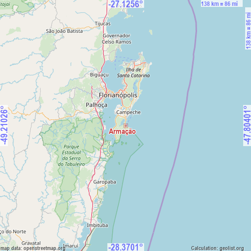
Armação GPS coordinates[2]
27° 44' 58.668" South, 48° 30' 25.668" West
| Map corner | latitude | longitude |
|---|---|---|
| Upper-left | -27.1256°, | -49.21026° |
| Center: | -27.74963°, | -48.50713° |
| Lower-right: | -28.3701°, | -47.80401° |
| Map W x H: | 138.4×138.4 km | = 86×86mi |
| max Lat: | 2.81972° ⇑93.3% North |
| Armação: | -27.74963° |
| min Lat: | ⇓6.7% South -33.69111° |
| min Long | Armação | max Long |
| -72.89583° | -48.50713° | -32.41083° |
| W 32.8%⇐ | ⇒67.2% E |
Elevation
Elevation of Armação is 4 m = 13 ft, and this is 376.9 m = 1237 ft below average elevation for this country.
| Max E: |
1603 m = 5259 ft | 99.3% |
| Avg. | 380.9 m = 1250 ft | |
| Armação | 4 m = 13 ft | |
Min E: |
0 m = 0 ft | 0.7% |
See also: Brazil elevation on elevation.city.
Geographical zone
Armação is located in South temperate zone (between Tropic of Capricorn and the Antarctic Circle). Distance of this Southern Tropic circle is 479.6 km =298 mi to North.| Distance of | km | miles | from Armação |
|---|---|---|---|
| Equator | 3085.5 | 1917.2 | to North |
| Tropic Capricorn | 479.6 | 298 | to North |
| Antarctic Circle | 4315.7 | 2681.7 | to South |
| South Pole | 6921.6 | 4300.9 | to South |


Nearby cities:
15 places around Armação: (largest is in red/bold)
• Acores
4 km =2.5 mi,  208°
208°
• Caiacanga da Barra do Sul
6.6 km =4.1 mi,  256°
256°
• Carianos
10.5 km =6.5 mi,  340°
340°
• Carvoeira
16.9 km =10.5 mi,  353°
353°
• Corrego Grande
16.5 km =10.3 mi,  0°
0°
• Costeira do Pirajubae
12.7 km =7.9 mi, 353°
• Florianópolis
17.5 km =10.9 mi, 346°
• Freguesia do Ribeirao da Ilha
6.5 km =4 mi,  302°
302°
• Lagoa
16.6 km =10.3 mi,  13°
13°
• Pantanal
15.6 km =9.7 mi,  356°
356°
• Pantano do Sul
3.3 km =2.1 mi,  182°
182°
• Ribeirão da Ilha
6.1 km =3.8 mi, 336°
• Rio Tavares
12 km =7.5 mi,  15°
15°
• Saco dos Limoes
15.9 km =9.9 mi, 349°
• Tapera
8.4 km =5.2 mi,  328°
328°
Sources, notices
• [Note1] Compared only with cities in Brazil existing in our database
• [Src1] Map data: © OpenStreetMap contributors (CC-BY-SA)
• [Src2] Other city data from geonames.org with taken over terms of usage.
• [Src3] Geographical zone / Annual Mean Temperature by Robert A. Rohde @ Wikipedia
