Manaus geodata
Manaus (Amazonas) is a seat of a first-order administrative division; located in Brazil in America/Manaus (GMT-4) time zone. With population of 1,598,210 people, there are 7 cities with bigger population in this country. Compared to other cities in Brazil, 95.1% of cities are located further ↓South; 97.2% of cities are located further →East and 88.9% of cities have higher elevation than Manaus. Note1


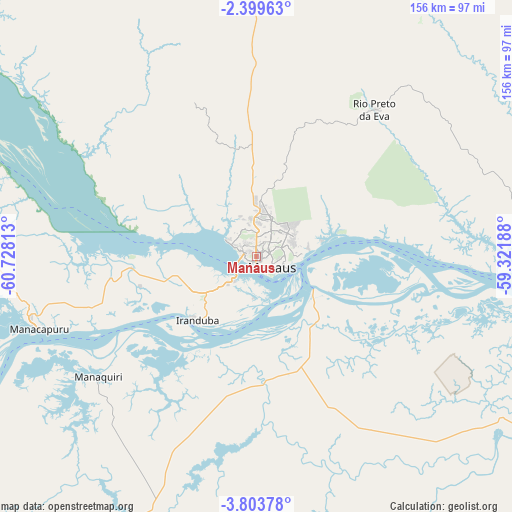
Manaus GPS coordinates[2]
3° 6' 6.984" South, 60° 1' 30" West
| Map corner | latitude | longitude |
|---|---|---|
| Upper-left | -2.39963°, | -60.72813° |
| Center: | -3.10194°, | -60.025° |
| Lower-right: | -3.80378°, | -59.32188° |
| Map W x H: | 156.1×156.1 km | = 97×97mi |
| max Lat: | 2.81972° ⇑4.9% North |
| Manaus: | -3.10194° |
| min Lat: | ⇓95.1% South -33.69111° |
| min Long | Manaus | max Long |
| -72.89583° | -60.025° | -32.41083° |
| W 2.8%⇐ | ⇒97.2% E |
Elevation
Elevation of Manaus is 20 m = 66 ft, and this is 360.9 m = 1184 ft below average elevation for this country.
| Max E: |
1603 m = 5259 ft | 88.9% |
| Avg. | 380.9 m = 1250 ft | |
| Manaus | 20 m = 66 ft | |
Min E: |
0 m = 0 ft | 11.1% |
See also: Manaus elevation on elevation.city.
Geographical zone
Manaus is located in South Torrid zone (between Equator and Tropic of Capricorn). Distance of Equator is 344.9 km =214.3 mi to North.| Distance of | km | miles | from Manaus |
|---|---|---|---|
| Equator | 344.9 | 214.3 | to North |
| Tropic Capricorn | 2261 | 1404.9 | to South |
| Antarctic Circle | 7056.3 | 4384.6 | to South |
| South Pole | 9662.2 | 6003.8 | to South |


Nearby cities:
15 places around Manaus: (largest is in red/bold)
• Anori
194.6 km =120.9 mi,  247°
247°
• Autazes
112.6 km =70 mi,  118°
118°
• Borba
151.3 km =94 mi,  161°
161°
• Careiro da Várzea
24.4 km =15.2 mi, 115°
• Codajás
239.9 km =149.1 mi, 250°
• Iranduba
27.1 km =16.8 mi,  221°
221°
• Itacoatiara
175.6 km =109.1 mi,  91°
91°
• Manacapuru
69.7 km =43.3 mi, 251°
• Manaquiri
43.3 km =26.9 mi,  236°
236°
• Maués
257.9 km =160.3 mi,  96°
96°
• Nova Olinda do Norte
135.5 km =84.2 mi,  130°
130°
• Novo Aripuanã
227.9 km =141.6 mi,  189°
189°
• Rio Preto da Eva
57.5 km =35.7 mi,  38°
38°
• Urucará
259.3 km =161.1 mi,  75°
75°
• Urucurituba
207.2 km =128.7 mi, 90°
Sources, notices
• [Note1] Compared only with cities in Brazil existing in our database
• [Src1] Map data: © OpenStreetMap contributors (CC-BY-SA)
• [Src2] Other city data from geonames.org with taken over terms of usage.
• [Src3] Geographical zone / Annual Mean Temperature by Robert A. Rohde @ Wikipedia
