Michanovichi geodata
Michanovichi (Minsk) is a populated place; located in Belarus in Europe/Minsk (GMT+3) time zone. With population of 4,800 people, there are 139 cities with bigger population in this country. Compared to other cities in Belarus, 51% of cities are located further ↑North; 52% of cities are located further →East and 80.3% of cities have lower elevation than Michanovichi. Note1


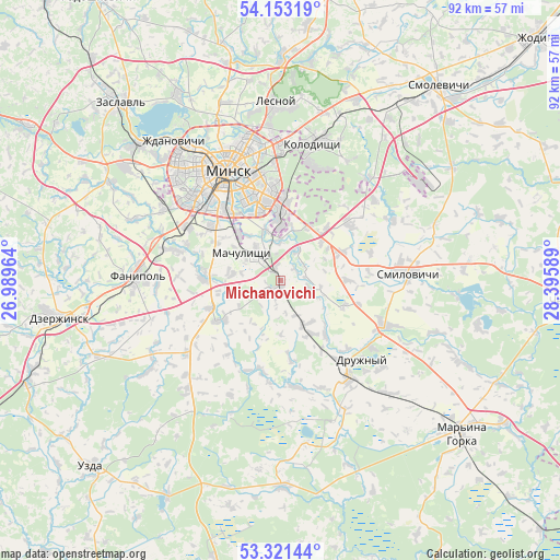
Michanovichi GPS coordinates[2]
53° 44' 21.732" North, 27° 41' 33.936" East
| Map corner | latitude | longitude |
|---|---|---|
| Upper-left | 54.15319°, | 26.98964° |
| Center: | 53.73937°, | 27.69276° |
| Lower-right: | 53.32144°, | 28.39589° |
| Map W x H: | 92.5×92.5 km | = 57.5×57.5mi |
| max Lat: | 56.0147° ⇑51% North |
| Michanovichi: | 53.73937° |
| min Lat: | ⇓49% South 51.75° |
| min Long | Michanovichi | max Long |
| 23.37083° | 27.69276° | 32.578° |
| W 48%⇐ | ⇒52% E |
Elevation
Elevation of Michanovichi is 193 m = 633 ft, and this is 24.4 m = 80 ft above average elevation for this country.
| Max E: |
309 m = 1014 ft | 19.7% |
| Michanovichi | 193 m 633 ft | |
| Avg. | 168.6 m = 553 ft | |
Min E: |
108 m = 354 ft | 80.3% |
See also: Belarus elevation on elevation.city.
Geographical zone
Michanovichi is located in North temperate zone (between Tropic of Cancer and the Arctic Circle). Distance of this North polar circle is 1425.9 km =886 mi to North.| Distance of | km | miles | from Michanovichi |
|---|---|---|---|
| North Pole | 4031.8 | 2505.2 | to North |
| Arctic Circle | 1425.9 | 886 | to North |
| Tropic Cancer | 3369.3 | 2093.6 | to South |
| Equator | 5975.3 | 3712.9 | to South |


Nearby cities:
15 places around Michanovichi: (largest is in red/bold)
• Atolina
17.6 km =10.9 mi,  285°
285°
• Bol’shoye Stiklevo
14.5 km =9 mi,  2°
2°
• Druzhny
18.6 km =11.6 mi,  133°
133°
• Dukora
17.6 km =10.9 mi,  112°
112°
• Hatava
5.9 km =3.7 mi,  324°
324°
• Luhavaya Slabada
11 km =6.8 mi,  64°
64°
• Machulishchy
7.8 km =4.8 mi,  304°
304°
• Pryvol’ny
9.4 km =5.8 mi,  46°
46°
• Samakhvalavichy
12.4 km =7.7 mi,  270°
270°
• Schomyslitsa
18.2 km =11.3 mi, 299°
• Svislach
18.6 km =11.6 mi, 126°
• Syenitsa
14.6 km =9.1 mi,  314°
314°
• Vyaliki Trastsyanets
12.5 km =7.8 mi,  6°
6°
• Yubilyeyny
14.3 km =8.9 mi, 308°
• Zamostochye
14.6 km =9.1 mi, 52°
Sources, notices
• [Note1] Compared only with cities in Belarus existing in our database
• [Src1] Map data: © OpenStreetMap contributors (CC-BY-SA)
• [Src2] Other city data from geonames.org with taken over terms of usage.
• [Src3] Geographical zone / Annual Mean Temperature by Robert A. Rohde @ Wikipedia
