Valer’yanovo geodata
Valer’yanovo (Minsk) is a populated place; located in Belarus in Europe/Minsk (GMT+3) time zone. With population of 790 people, there are 263 cities with bigger population in this country. Compared to other cities in Belarus, 64.8% of cities are located further ↓South; 53% of cities are located further →East and 96.4% of cities have lower elevation than Valer’yanovo. Note1


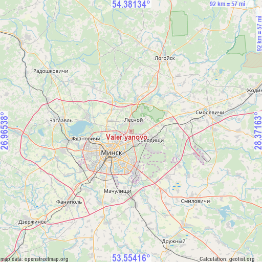
Valer’yanovo GPS coordinates[2]
53° 58' 11.28" North, 27° 40' 6.6" East
| Map corner | latitude | longitude |
|---|---|---|
| Upper-left | 54.38134°, | 26.96538° |
| Center: | 53.9698°, | 27.6685° |
| Lower-right: | 53.55416°, | 28.37163° |
| Map W x H: | 92×92 km | = 57.2×57.2mi |
| max Lat: | 56.0147° ⇑35.2% North |
| Valer’yanovo: | 53.9698° |
| min Lat: | ⇓64.8% South 51.75° |
| min Long | Valer’yanovo | max Long |
| 23.37083° | 27.6685° | 32.578° |
| W 47%⇐ | ⇒53% E |
Elevation
Elevation of Valer’yanovo is 233 m = 764 ft, and this is 64.4 m = 211 ft above average elevation for this country.
| Max E: |
309 m = 1014 ft | 3.6% |
| Valer’yanovo | 233 m 764 ft | |
| Avg. | 168.6 m = 553 ft | |
Min E: |
108 m = 354 ft | 96.4% |
See also: Belarus elevation on elevation.city.
Geographical zone
Valer’yanovo is located in North temperate zone (between Tropic of Cancer and the Arctic Circle). Distance of this North polar circle is 1400.3 km =870.1 mi to North.| Distance of | km | miles | from Valer’yanovo |
|---|---|---|---|
| North Pole | 4006.2 | 2489.3 | to North |
| Arctic Circle | 1400.3 | 870.1 | to North |
| Tropic Cancer | 3395 | 2109.6 | to South |
| Equator | 6000.9 | 3728.8 | to South |


Nearby cities:
15 places around Valer’yanovo: (largest is in red/bold)
• Astrashytski Haradok
10.7 km =6.6 mi,  9°
9°
• Bal’shavik
7.6 km =4.7 mi,  299°
299°
• Bol’shoye Stiklevo
11.4 km =7.1 mi,  169°
169°
• Borovlyany
3.6 km =2.2 mi, 7°
• Gorodishche
11.2 km =7 mi,  82°
82°
• Kalodzishchy
8 km =5 mi,  111°
111°
• Korolëv Stan
8.7 km =5.4 mi, 77°
• Lyasny
4.5 km =2.8 mi,  23°
23°
• Lyeskawka
4.6 km =2.9 mi,  37°
37°
• Minsk
10.2 km =6.3 mi,  220°
220°
• Slabada
14.9 km =9.3 mi,  73°
73°
• Syomkava
15.5 km =9.6 mi,  286°
286°
• Vyaliki Trastsyanets
13.5 km =8.4 mi, 167°
• Yukhnovka
12.4 km =7.7 mi,  87°
87°
• Zhdanovichy
16.2 km =10.1 mi,  259°
259°
Sources, notices
• [Note1] Compared only with cities in Belarus existing in our database
• [Src1] Map data: © OpenStreetMap contributors (CC-BY-SA)
• [Src2] Other city data from geonames.org with taken over terms of usage.
• [Src3] Geographical zone / Annual Mean Temperature by Robert A. Rohde @ Wikipedia
