Slabada geodata
Slabada (Minsk) is a populated place; located in Belarus in Europe/Minsk (GMT+3) time zone. With population of 1,819 people, there are 197 cities with bigger population in this country. Compared to other cities in Belarus, 69.4% of cities are located further ↓South; 54.6% of cities are located further ←West and 88.2% of cities have lower elevation than Slabada. Note1


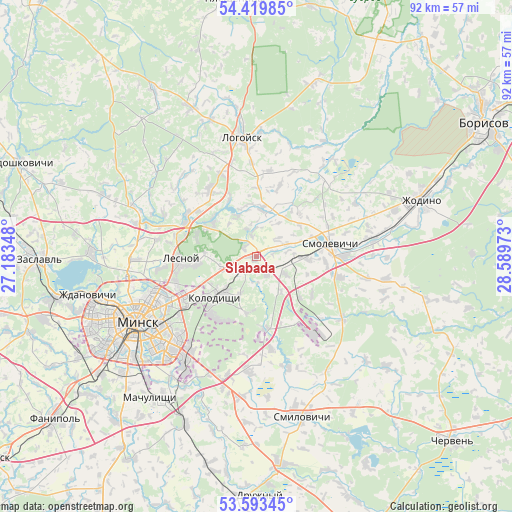
Slabada GPS coordinates[2]
54° 0' 31.32" North, 27° 53' 11.76" East
| Map corner | latitude | longitude |
|---|---|---|
| Upper-left | 54.41985°, | 27.18348° |
| Center: | 54.0087°, | 27.8866° |
| Lower-right: | 53.59345°, | 28.58973° |
| Map W x H: | 91.9×91.9 km | = 57.1×57.1mi |
| max Lat: | 56.0147° ⇑30.6% North |
| Slabada: | 54.0087° |
| min Lat: | ⇓69.4% South 51.75° |
| min Long | Slabada | max Long |
| 23.37083° | 27.8866° | 32.578° |
| W 54.6%⇐ | ⇒45.4% E |
Elevation
Elevation of Slabada is 205 m = 673 ft, and this is 36.4 m = 119 ft above average elevation for this country.
| Max E: |
309 m = 1014 ft | 11.8% |
| Slabada | 205 m 673 ft | |
| Avg. | 168.6 m = 553 ft | |
Min E: |
108 m = 354 ft | 88.2% |
See also: Belarus elevation on elevation.city.
Geographical zone
Slabada is located in North temperate zone (between Tropic of Cancer and the Arctic Circle). Distance of this North polar circle is 1396 km =867.4 mi to North.| Distance of | km | miles | from Slabada |
|---|---|---|---|
| North Pole | 4001.9 | 2486.7 | to North |
| Arctic Circle | 1396 | 867.4 | to North |
| Tropic Cancer | 3399.3 | 2112.2 | to South |
| Equator | 6005.2 | 3731.5 | to South |


Nearby cities:
15 places around Slabada: (largest is in red/bold)
• Astrashytski Haradok
14 km =8.7 mi,  296°
296°
• Bol’shoye Stiklevo
19.7 km =12.2 mi,  218°
218°
• Borovlyany
13.8 km =8.6 mi,  267°
267°
• Gorodishche
4.2 km =2.6 mi,  228°
228°
• Horad Smalyavichy
13.4 km =8.3 mi,  82°
82°
• Kalodzishchy
9.9 km =6.2 mi, 223°
• Korolëv Stan
6.3 km =3.9 mi,  246°
246°
• Lyasny
12.4 km =7.7 mi, 269°
• Lyeskawka
11.5 km =7.1 mi, 266°
• Usiazh
10.9 km =6.8 mi,  46°
46°
• Valer’yanovo
14.9 km =9.3 mi, 253°
• Vyaliki Trastsyanets
20.9 km =13 mi,  212°
212°
• Yukhnovka
4.1 km =2.5 mi, 206°
• Zabalotstsye
9.2 km =5.7 mi,  92°
92°
• Октябрьский
20.7 km =12.9 mi, 80°
Sources, notices
• [Note1] Compared only with cities in Belarus existing in our database
• [Src1] Map data: © OpenStreetMap contributors (CC-BY-SA)
• [Src2] Other city data from geonames.org with taken over terms of usage.
• [Src3] Geographical zone / Annual Mean Temperature by Robert A. Rohde @ Wikipedia
