Smarhon’ geodata
Smarhon’ (Grodnenskaya) is a seat of a second-order administrative division; located in Belarus in Europe/Minsk (GMT+3) time zone. With population of 36,900 people, there are 26 cities with bigger population in this country. Compared to other cities in Belarus, 85.2% of cities are located further ↓South; 77% of cities are located further →East and 63.5% of cities have higher elevation than Smarhon’. Note1


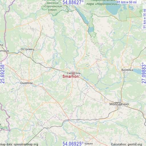
Smarhon’ GPS coordinates[2]
54° 28' 47.28" North, 26° 23' 44.52" East
| Map corner | latitude | longitude |
|---|---|---|
| Upper-left | 54.88627°, | 25.69258° |
| Center: | 54.4798°, | 26.3957° |
| Lower-right: | 54.06925°, | 27.09883° |
| Map W x H: | 90.8×90.8 km | = 56.4×56.4mi |
| max Lat: | 56.0147° ⇑14.8% North |
| Smarhon’: | 54.4798° |
| min Lat: | ⇓85.2% South 51.75° |
| min Long | Smarhon’ | max Long |
| 23.37083° | 26.3957° | 32.578° |
| W 23%⇐ | ⇒77% E |
Elevation
Elevation of Smarhon’ is 153 m = 502 ft, and this is 15.6 m = 51 ft below average elevation for this country.
| Max E: |
309 m = 1014 ft | 63.5% |
| Avg. | 168.6 m = 553 ft | |
| Smarhon’ | 153 m = 502 ft | |
Min E: |
108 m = 354 ft | 36.5% |
See also: Belarus elevation on elevation.city.
Geographical zone
Smarhon’ is located in North temperate zone (between Tropic of Cancer and the Arctic Circle). Distance of this North polar circle is 1343.6 km =834.9 mi to North.| Distance of | km | miles | from Smarhon’ |
|---|---|---|---|
| North Pole | 3949.5 | 2454.1 | to North |
| Arctic Circle | 1343.6 | 834.9 | to North |
| Tropic Cancer | 3451.7 | 2144.8 | to South |
| Equator | 6057.6 | 3764 | to South |


Nearby cities:
15 places around Smarhon’: (largest is in red/bold)
• Ashmyany
30.4 km =18.9 mi,  257°
257°
• Astravyets
32.1 km =19.9 mi,  297°
297°
• Baruny
24.6 km =15.3 mi,  222°
222°
• Hal’shany
34.9 km =21.7 mi,  225°
225°
• Kreva
19.9 km =12.4 mi,  199°
199°
• Maladzyechna
34.8 km =21.6 mi,  121°
121°
• Narach
23.7 km =14.7 mi,  66°
66°
• Nasilava
31.7 km =19.7 mi,  127°
127°
• Soly
13.5 km =8.4 mi,  285°
285°
• Svir
41.4 km =25.7 mi,  359°
359°
• Turets-Bayary
20.4 km =12.7 mi, 123°
• Valozhyn
44.3 km =27.5 mi,  168°
168°
• Vilyeyka
33.3 km =20.7 mi,  87°
87°
• Vishnyeva
26.9 km =16.7 mi,  17°
17°
• Zalyessye
11.9 km =7.4 mi, 124°
Sources, notices
• [Note1] Compared only with cities in Belarus existing in our database
• [Src1] Map data: © OpenStreetMap contributors (CC-BY-SA)
• [Src2] Other city data from geonames.org with taken over terms of usage.
• [Src3] Geographical zone / Annual Mean Temperature by Robert A. Rohde @ Wikipedia
