Maladzyechna geodata
Maladzyechna (Minsk) is a seat of a second-order administrative division; located in Belarus in Europe/Minsk (GMT+3) time zone. With population of 101,300 people, there are 13 cities with bigger population in this country. Compared to other cities in Belarus, 80.3% of cities are located further ↓South; 68.7% of cities are located further →East and 54.3% of cities have higher elevation than Maladzyechna. Note1


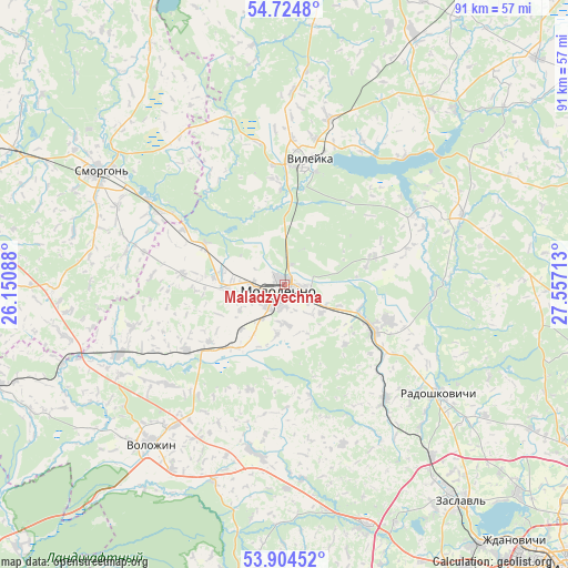
Maladzyechna GPS coordinates[2]
54° 19' 0.12" North, 26° 51' 14.4" East
| Map corner | latitude | longitude |
|---|---|---|
| Upper-left | 54.7248°, | 26.15088° |
| Center: | 54.3167°, | 26.854° |
| Lower-right: | 53.90452°, | 27.55713° |
| Map W x H: | 91.2×91.2 km | = 56.7×56.7mi |
| max Lat: | 56.0147° ⇑19.7% North |
| Maladzyechna: | 54.3167° |
| min Lat: | ⇓80.3% South 51.75° |
| min Long | Maladzyechna | max Long |
| 23.37083° | 26.854° | 32.578° |
| W 31.3%⇐ | ⇒68.7% E |
Elevation
Elevation of Maladzyechna is 161 m = 528 ft, and this is 7.6 m = 25 ft below average elevation for this country.
| Max E: |
309 m = 1014 ft | 54.3% |
| Avg. | 168.6 m = 553 ft | |
| Maladzyechna | 161 m = 528 ft | |
Min E: |
108 m = 354 ft | 45.7% |
See also: Maladzyechna elevation on elevation.city.
Geographical zone
Maladzyechna is located in North temperate zone (between Tropic of Cancer and the Arctic Circle). Distance of this North polar circle is 1361.7 km =846.1 mi to North.| Distance of | km | miles | from Maladzyechna |
|---|---|---|---|
| North Pole | 3967.6 | 2465.4 | to North |
| Arctic Circle | 1361.7 | 846.1 | to North |
| Tropic Cancer | 3433.5 | 2133.5 | to South |
| Equator | 6039.5 | 3752.8 | to South |


Nearby cities:
15 places around Maladzyechna: (largest is in red/bold)
• Chyst’
17.2 km =10.7 mi,  107°
107°
• Il’ya
30.7 km =19.1 mi,  68°
68°
• Krasnaye
16.5 km =10.3 mi,  119°
119°
• Kreva
36.5 km =22.7 mi,  269°
269°
• Narach
28.7 km =17.8 mi,  343°
343°
• Nasilava
4.9 km =3 mi,  253°
253°
• Pyatryshki
36.4 km =22.6 mi,  139°
139°
• Radashkovichy
30.9 km =19.2 mi,  125°
125°
• Rakaw
41 km =25.5 mi,  161°
161°
• Smarhon’
34.8 km =21.6 mi,  301°
301°
• Turets-Bayary
14.4 km =8.9 mi, 298°
• Valozhyn
33.1 km =20.6 mi,  220°
220°
• Vilyeyka
19.8 km =12.3 mi,  10°
10°
• Zalyessye
22.9 km =14.2 mi, 299°
• Zaslawye
43.4 km =27 mi, 141°
Sources, notices
• [Note1] Compared only with cities in Belarus existing in our database
• [Src1] Map data: © OpenStreetMap contributors (CC-BY-SA)
• [Src2] Other city data from geonames.org with taken over terms of usage.
• [Src3] Geographical zone / Annual Mean Temperature by Robert A. Rohde @ Wikipedia
