Slawharad geodata
Slawharad (Mogilev) is a seat of a second-order administrative division; located in Belarus in Europe/Minsk (GMT+3) time zone. With population of 8,300 people, there are 99 cities with bigger population in this country. Compared to other cities in Belarus, 64.5% of cities are located further ↑North; 95.1% of cities are located further ←West and 58.6% of cities have higher elevation than Slawharad. Note1


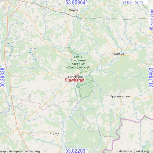
Slawharad GPS coordinates[2]
53° 26' 34.44" North, 31° 0' 5.04" East
| Map corner | latitude | longitude |
|---|---|---|
| Upper-left | 53.85964°, | 30.29828° |
| Center: | 53.4429°, | 31.0014° |
| Lower-right: | 53.02203°, | 31.70453° |
| Map W x H: | 93.1×93.1 km | = 57.8×57.8mi |
| max Lat: | 56.0147° ⇑64.5% North |
| Slawharad: | 53.4429° |
| min Lat: | ⇓35.5% South 51.75° |
| min Long | Slawharad | max Long |
| 23.37083° | 31.0014° | 32.578° |
| W 95.1%⇐ | ⇒4.9% E |
Elevation
Elevation of Slawharad is 158 m = 518 ft, and this is 10.6 m = 35 ft below average elevation for this country.
| Max E: |
309 m = 1014 ft | 58.6% |
| Avg. | 168.6 m = 553 ft | |
| Slawharad | 158 m = 518 ft | |
Min E: |
108 m = 354 ft | 41.4% |
See also: Belarus elevation on elevation.city.
Geographical zone
Slawharad is located in North temperate zone (between Tropic of Cancer and the Arctic Circle). Distance of this North polar circle is 1458.9 km =906.5 mi to North.| Distance of | km | miles | from Slawharad |
|---|---|---|---|
| North Pole | 4064.8 | 2525.7 | to North |
| Arctic Circle | 1458.9 | 906.5 | to North |
| Tropic Cancer | 3336.4 | 2073.1 | to South |
| Equator | 5942.3 | 3692.4 | to South |


Nearby cities:
15 places around Slawharad: (largest is in red/bold)
• Bykhaw
50.8 km =31.6 mi,  279°
279°
• Chavusy
40.8 km =25.4 mi,  357°
357°
• Cherykaw
28.9 km =18 mi,  60°
60°
• Dowsk
48 km =29.8 mi,  228°
228°
• Harbavichy
46.2 km =28.7 mi,  334°
334°
• Horad Krychaw
55 km =34.2 mi, 58°
• Kadino
58.4 km =36.3 mi, 327°
• Karma
37.2 km =23.1 mi,  200°
200°
• Krasnapollye
29 km =18 mi,  114°
114°
• Krasnyy Bereg
55.1 km =34.2 mi,  256°
256°
• Krychaw
55.9 km =34.7 mi, 57°
• Novosëlki
58.2 km =36.2 mi,  314°
314°
• Posëlok Voskhod
56.8 km =35.3 mi, 310°
• Ramanavichy
55.3 km =34.4 mi, 328°
• Ryasno, Рясно, Расна
39.2 km =24.4 mi,  319°
319°
Sources, notices
• [Note1] Compared only with cities in Belarus existing in our database
• [Src1] Map data: © OpenStreetMap contributors (CC-BY-SA)
• [Src2] Other city data from geonames.org with taken over terms of usage.
• [Src3] Geographical zone / Annual Mean Temperature by Robert A. Rohde @ Wikipedia
