Karma geodata
Karma (Gomel Oblast) is a seat of a second-order administrative division; located in Belarus in Europe/Minsk (GMT+3) time zone. In our database, there are 292 cities with bigger population. Compared to other cities in Belarus, 73.4% of cities are located further ↑North; 92.8% of cities are located further ←West and 62.5% of cities have higher elevation than Karma. Note1


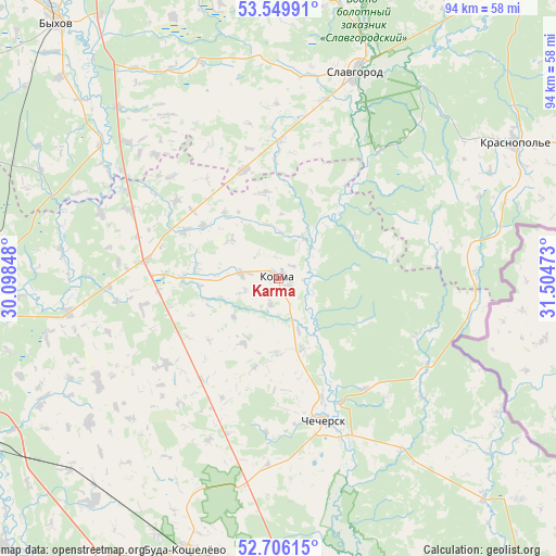
Karma GPS coordinates[2]
53° 7' 48.36" North, 30° 48' 5.76" East
| Map corner | latitude | longitude |
|---|---|---|
| Upper-left | 53.54991°, | 30.09848° |
| Center: | 53.1301°, | 30.8016° |
| Lower-right: | 52.70615°, | 31.50473° |
| Map W x H: | 93.8×93.8 km | = 58.3×58.3mi |
| max Lat: | 56.0147° ⇑73.4% North |
| Karma: | 53.1301° |
| min Lat: | ⇓26.6% South 51.75° |
| min Long | Karma | max Long |
| 23.37083° | 30.8016° | 32.578° |
| W 92.8%⇐ | ⇒7.2% E |
Elevation
Elevation of Karma is 155 m = 509 ft, and this is 13.6 m = 45 ft below average elevation for this country.
| Max E: |
309 m = 1014 ft | 62.5% |
| Avg. | 168.6 m = 553 ft | |
| Karma | 155 m = 509 ft | |
Min E: |
108 m = 354 ft | 37.5% |
See also: Belarus elevation on elevation.city.
Geographical zone
Karma is located in North temperate zone (between Tropic of Cancer and the Arctic Circle). Distance of this North polar circle is 1493.7 km =928.1 mi to North.| Distance of | km | miles | from Karma |
|---|---|---|---|
| North Pole | 4099.5 | 2547.3 | to North |
| Arctic Circle | 1493.7 | 928.1 | to North |
| Tropic Cancer | 3301.6 | 2051.5 | to South |
| Equator | 5907.5 | 3670.7 | to South |


Nearby cities:
15 places around Karma: (largest is in red/bold)
• Buda-Kashalyova
48.4 km =30.1 mi,  198°
198°
• Bykhaw
57 km =35.4 mi,  319°
319°
• Chachersk
25 km =15.5 mi,  161°
161°
• Cherykaw
62.2 km =38.6 mi,  38°
38°
• Dashkawka
76.2 km =47.3 mi,  332°
332°
• Dowsk
23 km =14.3 mi,  277°
277°
• Kastsyukowka
66.2 km =41.1 mi,  173°
173°
• Khal’ch
66.8 km =41.5 mi, 160°
• Krasnapollye
45.9 km =28.5 mi,  60°
60°
• Krasnyy Bereg
46.2 km =28.7 mi,  298°
298°
• Rahachow
50.4 km =31.3 mi,  265°
265°
• Ryasno, Рясно, Расна
65.8 km =40.9 mi,  349°
349°
• Slawharad
37.2 km =23.1 mi,  20°
20°
• Vyetka
68.4 km =42.5 mi, 158°
• Zhlobin
58.3 km =36.2 mi,  243°
243°
Sources, notices
• [Note1] Compared only with cities in Belarus existing in our database
• [Src1] Map data: © OpenStreetMap contributors (CC-BY-SA)
• [Src2] Other city data from geonames.org with taken over terms of usage.
• [Src3] Geographical zone / Annual Mean Temperature by Robert A. Rohde @ Wikipedia
