Myory geodata
Myory (Vitebsk) is a seat of a second-order administrative division; located in Belarus in Europe/Minsk (GMT+3) time zone. With population of 10,649 people, there are 77 cities with bigger population in this country. Compared to other cities in Belarus, 98.4% of cities are located further ↓South; 53.6% of cities are located further →East and 75.3% of cities have higher elevation than Myory. Note1


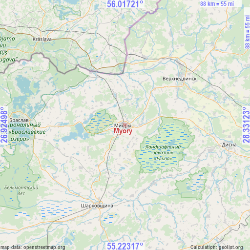
Myory GPS coordinates[2]
55° 37' 19.92" North, 27° 37' 41.16" East
| Map corner | latitude | longitude |
|---|---|---|
| Upper-left | 56.01721°, | 26.92498° |
| Center: | 55.6222°, | 27.6281° |
| Lower-right: | 55.22317°, | 28.33123° |
| Map W x H: | 88.3×88.3 km | = 54.9×54.9mi |
| max Lat: | 56.0147° ⇑1.6% North |
| Myory: | 55.6222° |
| min Lat: | ⇓98.4% South 51.75° |
| min Long | Myory | max Long |
| 23.37083° | 27.6281° | 32.578° |
| W 46.4%⇐ | ⇒53.6% E |
Elevation
Elevation of Myory is 146 m = 479 ft, and this is 22.6 m = 74 ft below average elevation for this country.
| Max E: |
309 m = 1014 ft | 75.3% |
| Avg. | 168.6 m = 553 ft | |
| Myory | 146 m = 479 ft | |
Min E: |
108 m = 354 ft | 24.7% |
See also: Belarus elevation on elevation.city.
Geographical zone
Myory is located in North temperate zone (between Tropic of Cancer and the Arctic Circle). Distance of this North polar circle is 1216.6 km =756 mi to North.| Distance of | km | miles | from Myory |
|---|---|---|---|
| North Pole | 3822.5 | 2375.2 | to North |
| Arctic Circle | 1216.6 | 756 | to North |
| Tropic Cancer | 3578.7 | 2223.7 | to South |
| Equator | 6184.6 | 3842.9 | to South |


Nearby cities:
15 places around Myory: (largest is in red/bold)
• Braslaw
36.9 km =22.9 mi,  273°
273°
• Druya
21.8 km =13.5 mi,  329°
329°
• Dzisna
36.9 km =22.9 mi,  99°
99°
• Hlybokaye
53.9 km =33.5 mi,  175°
175°
• Mosar
45.6 km =28.3 mi,  193°
193°
• Navapolatsk
61.8 km =38.4 mi, 99°
• Opsa
51.5 km =32 mi,  259°
259°
• Osveya
53 km =32.9 mi,  34°
34°
• Pastavy
75.4 km =46.9 mi,  221°
221°
• Polatsk
74.3 km =46.2 mi, 101°
• Sharkawshchyna
29.9 km =18.6 mi,  199°
199°
• Ushachy
79.5 km =49.4 mi,  128°
128°
• Vidzy
67.7 km =42.1 mi,  248°
248°
• Vyerkhnyadzvinsk
26 km =16.2 mi,  48°
48°
• Yazna
39.8 km =24.7 mi,  123°
123°
Sources, notices
• [Note1] Compared only with cities in Belarus existing in our database
• [Src1] Map data: © OpenStreetMap contributors (CC-BY-SA)
• [Src2] Other city data from geonames.org with taken over terms of usage.
• [Src3] Geographical zone / Annual Mean Temperature by Robert A. Rohde @ Wikipedia
