Luninyets geodata
Luninyets (Brest) is a seat of a second-order administrative division; located in Belarus in Europe/Minsk (GMT+3) time zone. With population of 25,000 people, there are 34 cities with bigger population in this country. Compared to other cities in Belarus, 90.1% of cities are located further ↑North; 70.1% of cities are located further →East and 85.9% of cities have higher elevation than Luninyets. Note1


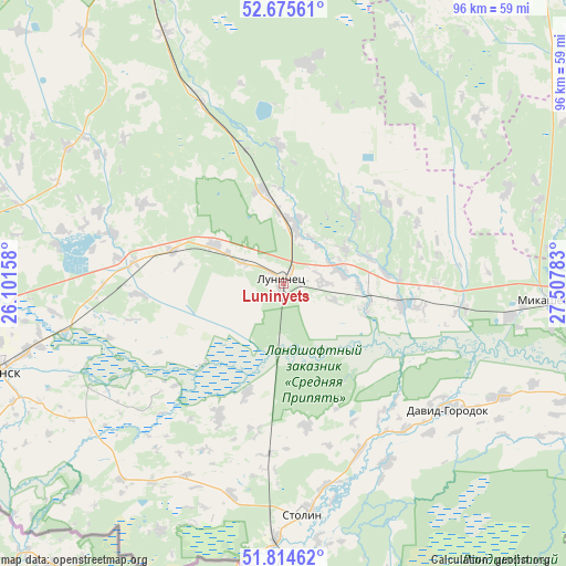
Luninyets GPS coordinates[2]
52° 14' 49.92" North, 26° 48' 16.92" East
| Map corner | latitude | longitude |
|---|---|---|
| Upper-left | 52.67561°, | 26.10158° |
| Center: | 52.2472°, | 26.8047° |
| Lower-right: | 51.81462°, | 27.50783° |
| Map W x H: | 95.7×95.7 km | = 59.5×59.5mi |
| max Lat: | 56.0147° ⇑90.1% North |
| Luninyets: | 52.2472° |
| min Lat: | ⇓9.9% South 51.75° |
| min Long | Luninyets | max Long |
| 23.37083° | 26.8047° | 32.578° |
| W 29.9%⇐ | ⇒70.1% E |
Elevation
Elevation of Luninyets is 139 m = 456 ft, and this is 29.6 m = 97 ft below average elevation for this country.
| Max E: |
309 m = 1014 ft | 85.9% |
| Avg. | 168.6 m = 553 ft | |
| Luninyets | 139 m = 456 ft | |
Min E: |
108 m = 354 ft | 14.1% |
See also: Belarus elevation on elevation.city.
Geographical zone
Luninyets is located in North temperate zone (between Tropic of Cancer and the Arctic Circle). Distance of this North polar circle is 1591.8 km =989.1 mi to North.| Distance of | km | miles | from Luninyets |
|---|---|---|---|
| North Pole | 4197.7 | 2608.3 | to North |
| Arctic Circle | 1591.8 | 989.1 | to North |
| Tropic Cancer | 3203.4 | 1990.5 | to South |
| Equator | 5809.3 | 3609.7 | to South |


Nearby cities:
15 places around Luninyets: (largest is in red/bold)
• Asnyezhytsy
46.4 km =28.8 mi,  262°
262°
• Chyrvonaya Slabada
71.7 km =44.6 mi,  20°
20°
• Davyd-Haradok
35.2 km =21.9 mi,  127°
127°
• Hantsavichy
62.2 km =38.6 mi,  335°
335°
• Horad Luninyets
0.5 km =0.3 mi,  313°
313°
• Horad Pinsk
51.8 km =32.2 mi,  254°
254°
• Hotsk
38 km =23.6 mi,  36°
36°
• Lahishyn
56.6 km =35.2 mi,  280°
280°
• Mikashevichy
45.8 km =28.5 mi,  94°
94°
• Pinsk
50.3 km =31.3 mi, 254°
• Starobin
69.4 km =43.1 mi, 39°
• Stolin
39.7 km =24.7 mi,  175°
175°
• Tsyelyakhany
71.9 km =44.7 mi,  294°
294°
• Turaw
66.5 km =41.3 mi,  107°
107°
• Zhytkavichy
71.7 km =44.6 mi, 92°
Sources, notices
• [Note1] Compared only with cities in Belarus existing in our database
• [Src1] Map data: © OpenStreetMap contributors (CC-BY-SA)
• [Src2] Other city data from geonames.org with taken over terms of usage.
• [Src3] Geographical zone / Annual Mean Temperature by Robert A. Rohde @ Wikipedia
