Davyd-Haradok geodata
Davyd-Haradok (Brest) is a populated place; located in Belarus in Europe/Minsk (GMT+3) time zone. With population of 7,694 people, there are 111 cities with bigger population in this country. Compared to other cities in Belarus, 96.4% of cities are located further ↑North; 63.5% of cities are located further →East and 93.1% of cities have higher elevation than Davyd-Haradok. Note1


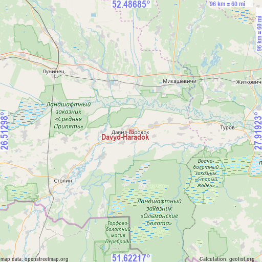
Davyd-Haradok GPS coordinates[2]
52° 3' 23.76" North, 27° 12' 57.96" East
| Map corner | latitude | longitude |
|---|---|---|
| Upper-left | 52.48685°, | 26.51298° |
| Center: | 52.0566°, | 27.2161° |
| Lower-right: | 51.62217°, | 27.91923° |
| Map W x H: | 96.1×96.1 km | = 59.7×59.7mi |
| max Lat: | 56.0147° ⇑96.4% North |
| Davyd-Haradok: | 52.0566° |
| min Lat: | ⇓3.6% South 51.75° |
| min Long | Davyd-Haradok | max Long |
| 23.37083° | 27.2161° | 32.578° |
| W 36.5%⇐ | ⇒63.5% E |
Elevation
Elevation of Davyd-Haradok is 130 m = 427 ft, and this is 38.6 m = 127 ft below average elevation for this country.
| Max E: |
309 m = 1014 ft | 93.1% |
| Avg. | 168.6 m = 553 ft | |
| Davyd-Haradok | 130 m = 427 ft | |
Min E: |
108 m = 354 ft | 6.9% |
See also: Belarus elevation on elevation.city.
Geographical zone
Davyd-Haradok is located in North temperate zone (between Tropic of Cancer and the Arctic Circle). Distance of this North polar circle is 1613 km =1002.3 mi to North.| Distance of | km | miles | from Davyd-Haradok |
|---|---|---|---|
| North Pole | 4218.9 | 2621.5 | to North |
| Arctic Circle | 1613 | 1002.3 | to North |
| Tropic Cancer | 3182.2 | 1977.3 | to South |
| Equator | 5788.2 | 3596.6 | to South |


Nearby cities:
15 places around Davyd-Haradok: (largest is in red/bold)
• Asnyezhytsy
75.6 km =47 mi,  281°
281°
• Chyrvonaya Slabada
88.5 km =55 mi,  357°
357°
• Horad Luninyets
35.7 km =22.2 mi,  307°
307°
• Horad Pinsk
78.4 km =48.7 mi, 275°
• Hotsk
52 km =32.3 mi,  354°
354°
• Luninyets
35.2 km =21.9 mi, 307°
• Lyel’chytsy
82 km =51 mi,  111°
111°
• Mikashevichy
25.2 km =15.7 mi,  44°
44°
• Pinsk
76.9 km =47.8 mi, 275°
• Pyetrykaw
87.5 km =54.4 mi,  84°
84°
• Salihorsk
84.2 km =52.3 mi,  15°
15°
• Starobin
76.3 km =47.4 mi,  12°
12°
• Stolin
31.3 km =19.4 mi,  234°
234°
• Turaw
35.5 km =22.1 mi,  87°
87°
• Zhytkavichy
47.2 km =29.3 mi,  67°
67°
Sources, notices
• [Note1] Compared only with cities in Belarus existing in our database
• [Src1] Map data: © OpenStreetMap contributors (CC-BY-SA)
• [Src2] Other city data from geonames.org with taken over terms of usage.
• [Src3] Geographical zone / Annual Mean Temperature by Robert A. Rohde @ Wikipedia
