Krasnosel’skiy geodata
Krasnosel’skiy (Grodnenskaya) is a populated place; located in Belarus in Europe/Minsk (GMT+3) time zone. With population of 7,300 people, there are 114 cities with bigger population in this country. Compared to other cities in Belarus, 68.7% of cities are located further ↑North; 93.4% of cities are located further →East and 96.4% of cities have higher elevation than Krasnosel’skiy. Note1


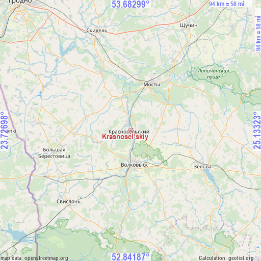
Krasnosel’skiy GPS coordinates[2]
53° 15' 52.2" North, 24° 25' 48.36" East
| Map corner | latitude | longitude |
|---|---|---|
| Upper-left | 53.68299°, | 23.72698° |
| Center: | 53.2645°, | 24.4301° |
| Lower-right: | 52.84187°, | 25.13323° |
| Map W x H: | 93.5×93.5 km | = 58.1×58.1mi |
| max Lat: | 56.0147° ⇑68.7% North |
| Krasnosel’skiy: | 53.2645° |
| min Lat: | ⇓31.3% South 51.75° |
| min Long | Krasnosel’ski | max Long |
| 23.37083° | 24.4301° | 32.578° |
| W 6.6%⇐ | ⇒93.4% E |
Elevation
Elevation of Krasnosel’skiy is 125 m = 410 ft, and this is 43.6 m = 143 ft below average elevation for this country.
| Max E: |
309 m = 1014 ft | 96.4% |
| Avg. | 168.6 m = 553 ft | |
| Krasnosel’skiy | 125 m = 410 ft | |
Min E: |
108 m = 354 ft | 3.6% |
See also: Belarus elevation on elevation.city.
Geographical zone
Krasnosel’skiy is located in North temperate zone (between Tropic of Cancer and the Arctic Circle). Distance of this North polar circle is 1478.7 km =918.8 mi to North.| Distance of | km | miles | from Krasnosel’skiy |
|---|---|---|---|
| North Pole | 4084.6 | 2538.1 | to North |
| Arctic Circle | 1478.7 | 918.8 | to North |
| Tropic Cancer | 3316.5 | 2060.8 | to South |
| Equator | 5922.5 | 3680.1 | to South |


Nearby cities:
15 places around Krasnosel’skiy: (largest is in red/bold)
• Azyory
53.4 km =33.2 mi,  342°
342°
• Hrodna
61.8 km =38.4 mi,  319°
319°
• Indura
42.4 km =26.3 mi,  300°
300°
• Mosty
17.9 km =11.1 mi,  23°
23°
• Ross’
2.8 km =1.7 mi, 321°
• Ruzhany
54.3 km =33.7 mi,  145°
145°
• Shchuchyn
42.9 km =26.7 mi,  29°
29°
• Skidel’
38.2 km =23.7 mi, 341°
• Slonim
62.3 km =38.7 mi,  108°
108°
• Svislach
33.8 km =21 mi,  220°
220°
• Volkovysk
12.1 km =7.5 mi,  173°
173°
• Vyalikaya Byerastavitsa
28.6 km =17.8 mi,  254°
254°
• Zel’va
28.6 km =17.8 mi,  116°
116°
• Zhaludok
52.1 km =32.4 mi,  44°
44°
• Zhirovichi
67.1 km =41.7 mi, 114°
Sources, notices
• [Note1] Compared only with cities in Belarus existing in our database
• [Src1] Map data: © OpenStreetMap contributors (CC-BY-SA)
• [Src2] Other city data from geonames.org with taken over terms of usage.
• [Src3] Geographical zone / Annual Mean Temperature by Robert A. Rohde @ Wikipedia
