Shchuchyn geodata
Shchuchyn (Grodnenskaya) is a seat of a second-order administrative division; located in Belarus in Europe/Minsk (GMT+3) time zone. With population of 15,700 people, there are 46 cities with bigger population in this country. Compared to other cities in Belarus, 57.6% of cities are located further ↑North; 92.1% of cities are located further →East and 62.5% of cities have lower elevation than Shchuchyn. Note1


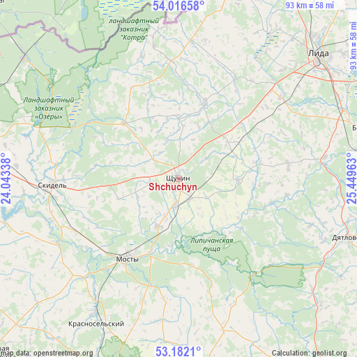
Shchuchyn GPS coordinates[2]
53° 36' 5.04" North, 24° 44' 47.4" East
| Map corner | latitude | longitude |
|---|---|---|
| Upper-left | 54.01658°, | 24.04338° |
| Center: | 53.6014°, | 24.7465° |
| Lower-right: | 53.1821°, | 25.44963° |
| Map W x H: | 92.8×92.8 km | = 57.7×57.7mi |
| max Lat: | 56.0147° ⇑57.6% North |
| Shchuchyn: | 53.6014° |
| min Lat: | ⇓42.4% South 51.75° |
| min Long | Shchuchyn | max Long |
| 23.37083° | 24.7465° | 32.578° |
| W 7.9%⇐ | ⇒92.1% E |
Elevation
Elevation of Shchuchyn is 176 m = 577 ft, and this is 7.4 m = 24 ft above average elevation for this country.
| Max E: |
309 m = 1014 ft | 37.5% |
| Shchuchyn | 176 m 577 ft | |
| Avg. | 168.6 m = 553 ft | |
Min E: |
108 m = 354 ft | 62.5% |
See also: Belarus elevation on elevation.city.
Geographical zone
Shchuchyn is located in North temperate zone (between Tropic of Cancer and the Arctic Circle). Distance of this North polar circle is 1441.3 km =895.6 mi to North.| Distance of | km | miles | from Shchuchyn |
|---|---|---|---|
| North Pole | 4047.1 | 2514.8 | to North |
| Arctic Circle | 1441.3 | 895.6 | to North |
| Tropic Cancer | 3354 | 2084.1 | to South |
| Equator | 5959.9 | 3703.3 | to South |


Nearby cities:
15 places around Shchuchyn: (largest is in red/bold)
• Azyory
39.4 km =24.5 mi,  289°
289°
• Byarozawka
51.3 km =31.9 mi,  74°
74°
• Byelagruda
35.5 km =22.1 mi,  51°
51°
• Dyatlovo
46.3 km =28.8 mi,  109°
109°
• Hrodna
61.5 km =38.2 mi,  279°
279°
• Indura
59.2 km =36.8 mi,  254°
254°
• Krasnosel’skiy
42.9 km =26.7 mi,  209°
209°
• Lida
48 km =29.8 mi, 49°
• Mosty
25.1 km =15.6 mi, 213°
• Ross’
41.9 km =26 mi, 212°
• Skidel’
32.9 km =20.4 mi,  267°
267°
• Volkovysk
53.2 km =33.1 mi,  201°
201°
• Vyalikaya Byerastavitsa
66.1 km =41.1 mi,  227°
227°
• Zel’va
50.4 km =31.3 mi,  174°
174°
• Zhaludok
15.6 km =9.7 mi,  91°
91°
Sources, notices
• [Note1] Compared only with cities in Belarus existing in our database
• [Src1] Map data: © OpenStreetMap contributors (CC-BY-SA)
• [Src2] Other city data from geonames.org with taken over terms of usage.
• [Src3] Geographical zone / Annual Mean Temperature by Robert A. Rohde @ Wikipedia
