Ivanava geodata
Ivanava (Brest) is a seat of a second-order administrative division; located in Belarus in Europe/Minsk (GMT+3) time zone. With population of 13,614 people, there are 55 cities with bigger population in this country. Compared to other cities in Belarus, 93.7% of cities are located further ↑North; 86.2% of cities are located further →East and 72% of cities have higher elevation than Ivanava. Note1


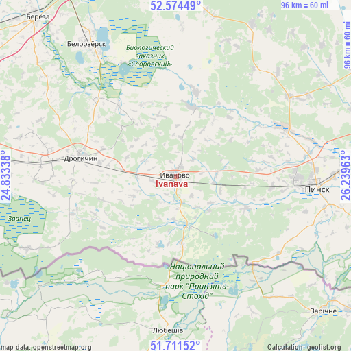
Ivanava GPS coordinates[2]
52° 8' 42.36" North, 25° 32' 11.4" East
| Map corner | latitude | longitude |
|---|---|---|
| Upper-left | 52.57449°, | 24.83338° |
| Center: | 52.1451°, | 25.5365° |
| Lower-right: | 51.71152°, | 26.23963° |
| Map W x H: | 96×96 km | = 59.7×59.7mi |
| max Lat: | 56.0147° ⇑93.7% North |
| Ivanava: | 52.1451° |
| min Lat: | ⇓6.3% South 51.75° |
| min Long | Ivanava | max Long |
| 23.37083° | 25.5365° | 32.578° |
| W 13.8%⇐ | ⇒86.2% E |
Elevation
Elevation of Ivanava is 148 m = 486 ft, and this is 20.6 m = 68 ft below average elevation for this country.
| Max E: |
309 m = 1014 ft | 72% |
| Avg. | 168.6 m = 553 ft | |
| Ivanava | 148 m = 486 ft | |
Min E: |
108 m = 354 ft | 28% |
See also: Belarus elevation on elevation.city.
Geographical zone
Ivanava is located in North temperate zone (between Tropic of Cancer and the Arctic Circle). Distance of this North polar circle is 1603.2 km =996.2 mi to North.| Distance of | km | miles | from Ivanava |
|---|---|---|---|
| North Pole | 4209.1 | 2615.4 | to North |
| Arctic Circle | 1603.2 | 996.2 | to North |
| Tropic Cancer | 3192.1 | 1983.5 | to South |
| Equator | 5798 | 3602.7 | to South |


Nearby cities:
15 places around Ivanava: (largest is in red/bold)
• Antopal’
51.6 km =32.1 mi,  277°
277°
• Asnyezhytsy
40.8 km =25.4 mi,  83°
83°
• Byaroza
57.3 km =35.6 mi,  318°
318°
• Byelaazyorsk
43.8 km =27.2 mi,  326°
326°
• Drahichyn
26.1 km =16.2 mi, 280°
• Horad Kobryn
80.2 km =49.8 mi, 275°
• Horad Pinsk
36.7 km =22.8 mi,  94°
94°
• Ivatsevichy
64.1 km =39.8 mi,  348°
348°
• Kobryn
80.8 km =50.2 mi, 275°
• Kosava
72.9 km =45.3 mi,  339°
339°
• Lahishyn
37.5 km =23.3 mi,  54°
54°
• Motal’
19.4 km =12.1 mi,  14°
14°
• Nyakhachava
59.9 km =37.2 mi, 337°
• Pinsk
38.2 km =23.7 mi, 93°
• Tsyelyakhany
46.3 km =28.8 mi,  26°
26°
Sources, notices
• [Note1] Compared only with cities in Belarus existing in our database
• [Src1] Map data: © OpenStreetMap contributors (CC-BY-SA)
• [Src2] Other city data from geonames.org with taken over terms of usage.
• [Src3] Geographical zone / Annual Mean Temperature by Robert A. Rohde @ Wikipedia
