Antopal’ geodata
Antopal’ (Brest) is a populated place; located in Belarus in Europe/Minsk (GMT+3) time zone. With population of 2,100 people, there are 185 cities with bigger population in this country. Compared to other cities in Belarus, 92.1% of cities are located further ↑North; 91.8% of cities are located further →East and 67.8% of cities have higher elevation than Antopal’. Note1


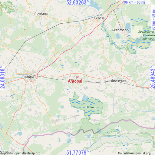
Antopal’ GPS coordinates[2]
52° 12' 13.68" North, 24° 47' 10.68" East
| Map corner | latitude | longitude |
|---|---|---|
| Upper-left | 52.63263°, | 24.08318° |
| Center: | 52.2038°, | 24.7863° |
| Lower-right: | 51.77079°, | 25.48943° |
| Map W x H: | 95.8×95.8 km | = 59.5×59.5mi |
| max Lat: | 56.0147° ⇑92.1% North |
| Antopal’: | 52.2038° |
| min Lat: | ⇓7.9% South 51.75° |
| min Long | Antopal’ | max Long |
| 23.37083° | 24.7863° | 32.578° |
| W 8.2%⇐ | ⇒91.8% E |
Elevation
Elevation of Antopal’ is 150 m = 492 ft, and this is 18.6 m = 61 ft below average elevation for this country.
| Max E: |
309 m = 1014 ft | 67.8% |
| Avg. | 168.6 m = 553 ft | |
| Antopal’ | 150 m = 492 ft | |
Min E: |
108 m = 354 ft | 32.2% |
See also: Belarus elevation on elevation.city.
Geographical zone
Antopal’ is located in North temperate zone (between Tropic of Cancer and the Arctic Circle). Distance of this North polar circle is 1596.7 km =992.1 mi to North.| Distance of | km | miles | from Antopal’ |
|---|---|---|---|
| North Pole | 4202.5 | 2611.3 | to North |
| Arctic Circle | 1596.7 | 992.1 | to North |
| Tropic Cancer | 3198.6 | 1987.5 | to South |
| Equator | 5804.5 | 3606.7 | to South |


Nearby cities:
15 places around Antopal’: (largest is in red/bold)
• Byaroza
38.7 km =24 mi,  19°
19°
• Byelaazyorsk
40.1 km =24.9 mi,  41°
41°
• Charnawchytsy
71.3 km =44.3 mi,  271°
271°
• Drahichyn
25.5 km =15.8 mi,  94°
94°
• Horad Kobryn
28.6 km =17.8 mi, 272°
• Ivanava
51.6 km =32.1 mi,  97°
97°
• Ivatsevichy
67.6 km =42 mi,  33°
33°
• Kamyanyets
69.9 km =43.4 mi,  288°
288°
• Kobryn
29.3 km =18.2 mi, 272°
• Kosava
66.5 km =41.3 mi, 22°
• Malaryta
67 km =41.6 mi,  226°
226°
• Motal’
57.2 km =35.5 mi,  77°
77°
• Nyakhachava
56.5 km =35.1 mi, 29°
• Pruzhany
45.1 km =28 mi,  330°
330°
• Zhabinka
52.8 km =32.8 mi, 269°
Sources, notices
• [Note1] Compared only with cities in Belarus existing in our database
• [Src1] Map data: © OpenStreetMap contributors (CC-BY-SA)
• [Src2] Other city data from geonames.org with taken over terms of usage.
• [Src3] Geographical zone / Annual Mean Temperature by Robert A. Rohde @ Wikipedia
