Kugluktuk geodata
Kugluktuk (Nunavut) is a populated locality; located in Canada in America/Cambridge_Bay (GMT-6) time zone. With population of 1,302 people, there are 920 cities with bigger population in this country. Compared to other cities in Canada, 99.5% of cities are located further ↓South; 83.2% of cities are located further →East and 99.7% of cities have higher elevation than Kugluktuk. Note1


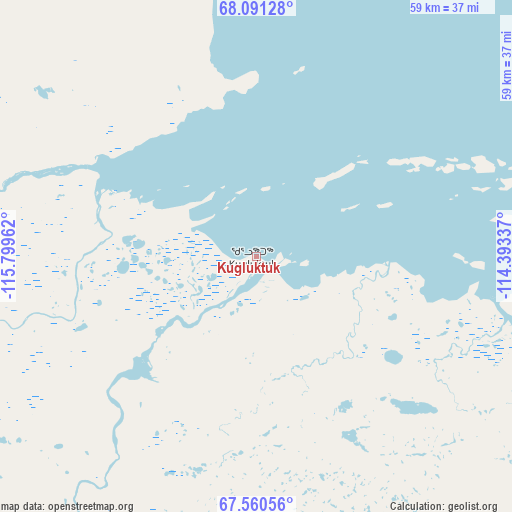
Kugluktuk GPS coordinates[2]
67° 49' 38.748" North, 115° 5' 47.364" West
| Map corner | latitude | longitude |
|---|---|---|
| Upper-left | 68.09128°, | -115.79962° |
| Center: | 67.82743°, | -115.09649° |
| Lower-right: | 67.56056°, | -114.39337° |
| Map W x H: | 59×59 km | = 36.7×36.7mi |
| max Lat: | 73.03752° ⇑0.5% North |
| Kugluktuk: | 67.82743° |
| min Lat: | ⇓99.5% South 42.05009° |
| min Long | Kugluktuk | max Long |
| -139.43328° | -115.09649° | -52.70931° |
| W 16.8%⇐ | ⇒83.2% E |
Elevation
Elevation of Kugluktuk is 1 m = 3 ft, and this is 253.4 m = 831 ft below average elevation for this country.
| Max E: |
1518 m = 4980 ft | 99.7% |
| Avg. | 254.4 m = 835 ft | |
| Kugluktuk | 1 m = 3 ft | |
Min E: |
-2 m = -7 ft | 0.3% |
See also: Canada elevation on elevation.city.
Geographical zone
Kugluktuk is located in North Frigid zone (between North Pole and Arctic Circle). Distance of this North polar circle is 140.5 km =87.3 mi to South.| Distance of | km | miles | from Kugluktuk |
|---|---|---|---|
| North Pole | 2465.4 | 1531.9 | to North |
| Arctic Circle | 140.5 | 87.3 | to South |
| Tropic Cancer | 4935.8 | 3067 | to South |
| Equator | 7541.7 | 4686.2 | to South |


Nearby cities:
15 places around Kugluktuk: (largest is in red/bold)
• Aklavik
826.2 km =513.4 mi,  273°
273°
• Behchokǫ̀
560.4 km =348.2 mi,  184°
184°
• Deline
469.5 km =291.7 mi,  231°
231°
• Fort Good Hope
611.3 km =379.8 mi,  253°
253°
• Fort Liard
935.2 km =581.1 mi,  205°
205°
• Fort McPherson
834.8 km =518.7 mi, 267°
• Fort Smith
883.6 km =549 mi,  169°
169°
• Gamèti
425.5 km =264.4 mi,  193°
193°
• Gjoa Haven
794.3 km =493.6 mi,  83°
83°
• Hay River
780.4 km =484.9 mi, 182°
• Inuvik
772 km =479.7 mi, 274°
• Nahanni Butte
852.1 km =529.5 mi, 207°
• Norman Wells
590 km =366.6 mi,  241°
241°
• Tuktoyaktuk
745.5 km =463.2 mi,  283°
283°
• Yellowknife
598.4 km =371.8 mi, 176°
Sources, notices
• [Note1] Compared only with cities in Canada existing in our database
• [Src1] Map data: © OpenStreetMap contributors (CC-BY-SA)
• [Src2] Other city data from geonames.org with taken over terms of usage.
• [Src3] Geographical zone / Annual Mean Temperature by Robert A. Rohde @ Wikipedia
