Rovio geodata
Rovio (Ticino) is a populated place; located in Switzerland in Europe/Zurich (GMT+2) time zone. With population of 729 people, there are 1561 cities with bigger population in this country. Compared to other cities in Switzerland, 99.2% of cities are located further ↑North; 87.9% of cities are located further ←West and 58.3% of cities have lower elevation than Rovio. Note1


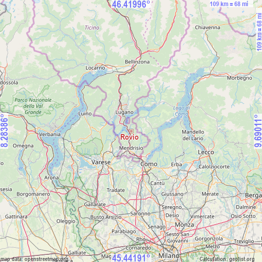
Rovio GPS coordinates[2]
45° 55' 59.124" North, 8° 59' 13.164" East
| Map corner | latitude | longitude |
|---|---|---|
| Upper-left | 46.41996°, | 8.28386° |
| Center: | 45.93309°, | 8.98699° |
| Lower-right: | 45.44191°, | 9.69011° |
| Map W x H: | 108.7×108.7 km | = 67.5×67.5mi |
| max Lat: | 47.76737° ⇑99.2% North |
| Rovio: | 45.93309° |
| min Lat: | ⇓0.8% South 45.83203° |
| min Long | Rovio | max Long |
| 5.97153° | 8.98699° | 10.44624° |
| W 87.9%⇐ | ⇒12.1% E |
Elevation
Elevation of Rovio is 509 m = 1670 ft, and this is 49.2 m = 161 ft below average elevation for this country.
| Max E: |
1845 m = 6053 ft | 41.7% |
| Avg. | 558.2 m = 1831 ft | |
| Rovio | 509 m = 1670 ft | |
Min E: |
197 m = 646 ft | 58.3% |
See also: Switzerland elevation on elevation.city.
Geographical zone
Rovio is located in North temperate zone (between Tropic of Cancer and the Arctic Circle). Distance of this North polar circle is 2293.9 km =1425.4 mi to North.| Distance of | km | miles | from Rovio |
|---|---|---|---|
| North Pole | 4899.8 | 3044.6 | to North |
| Arctic Circle | 2293.9 | 1425.4 | to North |
| Tropic Cancer | 2501.4 | 1554.3 | to South |
| Equator | 5107.3 | 3173.5 | to South |


Nearby cities:
15 places around Rovio: (largest is in red/bold)
• Arogno
2.9 km =1.8 mi,  356°
356°
• Arzo
7.3 km =4.5 mi,  209°
209°
• Capolago
3.3 km =2.1 mi,  190°
190°
• Castel San Pietro
8.1 km =5 mi,  168°
168°
• Ligornetto
8.4 km =5.2 mi,  198°
198°
• Lugano
8.8 km =5.5 mi,  346°
346°
• Melano
1.2 km =0.7 mi, 189°
• Melide
3.9 km =2.4 mi,  307°
307°
• Mendrisio
7 km =4.3 mi,  183°
183°
• Montagnola
7.7 km =4.8 mi,  316°
316°
• Morbio Superiore
8.6 km =5.3 mi,  160°
160°
• Morcote
5.6 km =3.5 mi,  260°
260°
• Riva San Vitale
3.7 km =2.3 mi, 198°
• Sorengo
8.1 km =5 mi,  332°
332°
• Viganello
9 km =5.6 mi, 351°
Sources, notices
• [Note1] Compared only with cities in Switzerland existing in our database
• [Src1] Map data: © OpenStreetMap contributors (CC-BY-SA)
• [Src2] Other city data from geonames.org with taken over terms of usage.
• [Src3] Geographical zone / Annual Mean Temperature by Robert A. Rohde @ Wikipedia
