Prangins geodata
Prangins (Vaud) is a populated place; located in Switzerland in Europe/Zurich (GMT+2) time zone. With population of 3,172 people, there are 556 cities with bigger population in this country. Compared to other cities in Switzerland, 88.1% of cities are located further ↑North; 97.5% of cities are located further →East and 83.8% of cities have higher elevation than Prangins. Note1


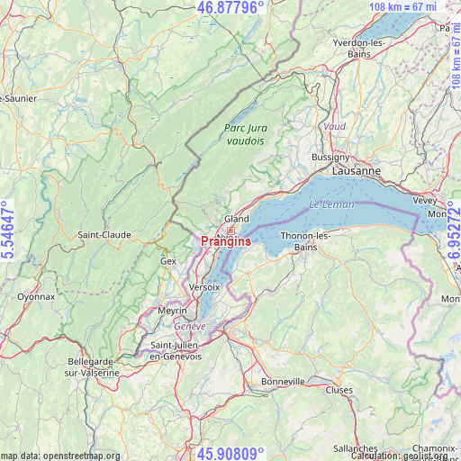
Prangins GPS coordinates[2]
46° 23' 42.648" North, 6° 14' 58.56" East
| Map corner | latitude | longitude |
|---|---|---|
| Upper-left | 46.87796°, | 5.54647° |
| Center: | 46.39518°, | 6.2496° |
| Lower-right: | 45.90809°, | 6.95272° |
| Map W x H: | 107.8×107.8 km | = 67×67mi |
| max Lat: | 47.76737° ⇑88.1% North |
| Prangins: | 46.39518° |
| min Lat: | ⇓11.9% South 45.83203° |
| min Long | Prangins | max Long |
| 5.97153° | 6.2496° | 10.44624° |
| W 2.5%⇐ | ⇒97.5% E |
Elevation
Elevation of Prangins is 413 m = 1355 ft, and this is 145.2 m = 476 ft below average elevation for this country.
| Max E: |
1845 m = 6053 ft | 83.8% |
| Avg. | 558.2 m = 1831 ft | |
| Prangins | 413 m = 1355 ft | |
Min E: |
197 m = 646 ft | 16.2% |
See also: Switzerland elevation on elevation.city.
Geographical zone
Prangins is located in North temperate zone (between Tropic of Cancer and the Arctic Circle). Distance of this North polar circle is 2242.5 km =1393.4 mi to North.| Distance of | km | miles | from Prangins |
|---|---|---|---|
| North Pole | 4848.4 | 3012.7 | to North |
| Arctic Circle | 2242.5 | 1393.4 | to North |
| Tropic Cancer | 2552.7 | 1586.2 | to South |
| Equator | 5158.7 | 3205.5 | to South |


Nearby cities:
15 places around Prangins: (largest is in red/bold)
• Arzier
7.8 km =4.8 mi,  336°
336°
• Begnins
5.2 km =3.2 mi,  358°
358°
• Bogis-Bossey
7.9 km =4.9 mi,  234°
234°
• Borex
5.9 km =3.7 mi,  252°
252°
• Bursins
7.2 km =4.5 mi,  26°
26°
• Chéserex
5.7 km =3.5 mi,  274°
274°
• Crassier
7 km =4.3 mi, 250°
• Céligny
6.5 km =4 mi,  220°
220°
• Eysins
3.6 km =2.2 mi, 245°
• Genolier
5.1 km =3.2 mi,  331°
331°
• Gilly
7.8 km =4.8 mi, 27°
• Gingins
5.7 km =3.5 mi,  285°
285°
• Gland
3.3 km =2.1 mi, 28°
• Nyon
1.5 km =0.9 mi,  210°
210°
• Trélex
3.9 km =2.4 mi,  305°
305°
Sources, notices
• [Note1] Compared only with cities in Switzerland existing in our database
• [Src1] Map data: © OpenStreetMap contributors (CC-BY-SA)
• [Src2] Other city data from geonames.org with taken over terms of usage.
• [Src3] Geographical zone / Annual Mean Temperature by Robert A. Rohde @ Wikipedia
